8 South America
8.1 Introducing the Realm
Learning Objectives
- Summarize the main physical features and characteristics of South America.
- Explain how European colonialism dominated the realm and divided up the continent.
- Describe the ethnic, economic, and political patterns in the Guianas.
- Outline the main cultural realms of South America. Describe each realm’s main majority and explain how colonialism impacted each region.
- Summarize how the South American countries are attempting to integrate their economies.
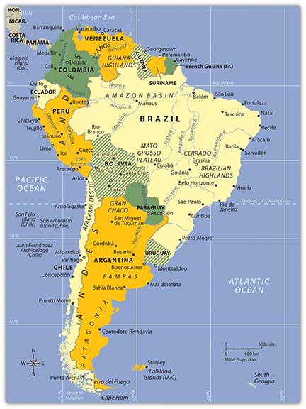
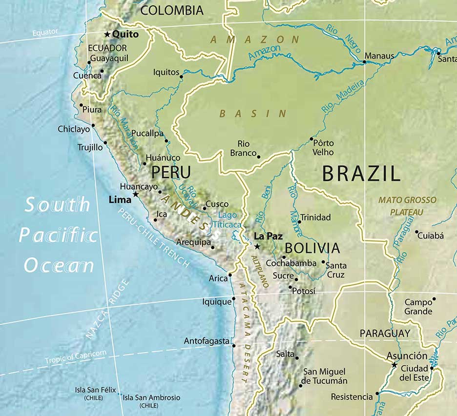
Europeans called the Western Hemisphere the New World. South America is the realm consisting of the southern portion of the New World. This realm includes the entire continent of South America, which is smaller in physical area than North America. As a continent, South America is larger in physical area than Europe, Antarctica, or Australia but is smaller than Africa or Asia. Almost the entire landmass of South America lies to the east of the same meridian that runs through Miami, Florida. The Atlantic Ocean borders the continent to the east and the Pacific Ocean borders the continent on the west. The narrow Isthmus of Panama creates a natural break between the South American continent and its neighbors to the north. The Caribbean Sea creates the northern boundary.
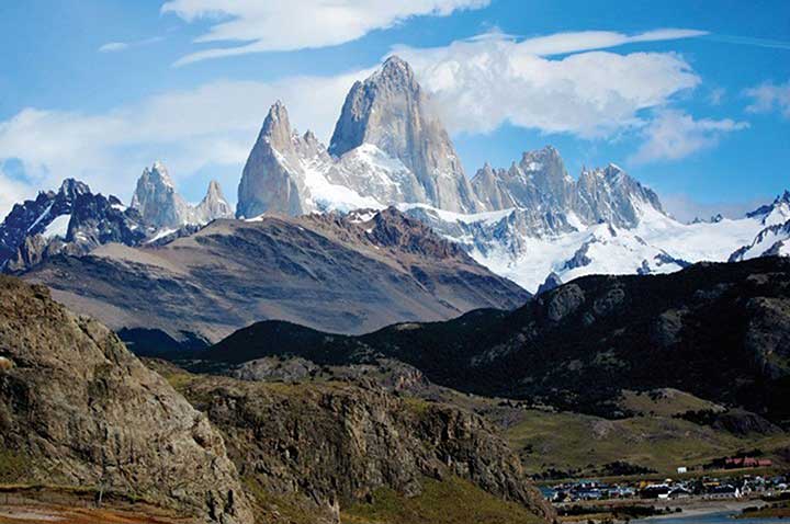
South America covers an extensive range of latitude. The equator cuts through the northern part of the continent directly through the mouth of the mighty Amazon River. The country of Ecuador is located on the equator—hence its name. The equatorial region is dominated by the tropical climates of the immense Amazon Basin. The Tropic of Capricorn runs directly through the latitude of São Paulo, Brazil, and Chile’s Atacama Desert, which reveals that most of the continent is in the zone of the tropics to the north. South of the Tropic of Capricorn is the Southern Cone of South America, home to the physical regions of the Pampas and Patagonia. Tierra del Fuego is the southern tip of the realm with territory in both Argentina and Chile. On the south side of the Tierra del Fuego archipelago is Cape Horn, which is the southernmost land point of the continent.
The continent of South America has a wide diversity of physical landscapes, from the high Andes Mountains to the tropical forests of the Amazon Basin. This assortment of physical features offers many resources, allowing people to engage in economic activity, gain wealth, and provide for their needs. The Andes hold mineral riches that have been extracted since ancient times. Precious metals have been mined from the mountains to grant great opportunities for those fortunate enough to be recipients of its wealth. Fossil fuels have been found in abundance in the far northern regions of Venezuela and Colombia. The Amazon Basin has been a source of hardwood lumber and, more recently, extensive mineral wealth. Some of the largest iron-ore mines in the world are located here. The massive plains of Brazil and the rich soils of the Pampas allow for enormous agricultural operations that provide food products for the continent and for the world. Even the inhospitable Atacama region in northern Chile holds some of the world’s largest copper reserves. In addition, the wide variety of climate zones allowed a diverse range of species to develop.
Before the era of European colonialism, many local groups organized themselves into states or empires. The Inca Empire was the largest in existence at the time the Europeans arrived. European colonialism altered the continent in several ways. Not only did the Europeans defeat and conquer indigenous Amerindian groups such as the Inca, but cultural exchanges also took place that altered the way of life for countless South Americans. Colonialism created many of the current country borders and influenced trade relationships with the newly created colonies. The plantation system and the introduction of slaves from Africa drastically changed the ethnic makeup of the people living along the eastern coast. After slavery was abolished, indentured servitude brought workers from Asia to support the labor base.
Indentured servants were usually poor individuals who agreed to work for an agreed upon period of time, usually less than seven years, in return for the necessities of life such as lodging, food, and transportation or clothing. These individuals did not usually receive a salary but may have received a lump sum payment upon completion of the agreed upon service. Under favorable conditions indentured servants were treated like relatives and gained important experience and job skills to provide for their future. Many situations were much less favorable and resembled a form of slavery where individuals suffered from disease, harsh conditions, or even succumbed to death.
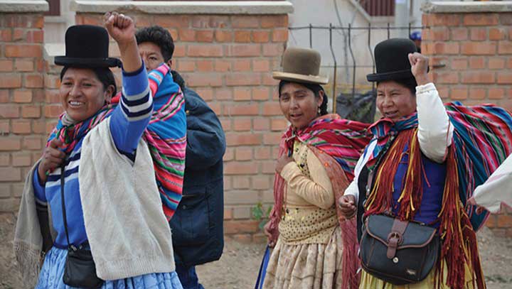
The continent can be divided into regions by ethnic majorities influenced by early colonial development. The mixing of ethnic groups from Europe, Africa, and Asia with each other or with the indigenous population has created a diverse cultural mosaic. For example, most people in Guyana and Suriname are from Asia, most people in Argentina and Uruguay are from Europe, most people in Peru and Bolivia are Amerindian, and most people in many areas along the eastern coast of Brazil are of African descent. A large percentage of the population of South America is of a mixed ethnic background.
South America’s modern economic development has helped integrate it with the global economy. The levels of economic development vary widely within the realm. There are clear indications of core-peripheral spatial patterns within various regions of the continent, and rural-to-urban shift has been strong in many areas. The rural regions in the Andes or the interior suffer from a lack of economic support needed to modernize their infrastructure. At the same time, metropolitan areas are expanding rapidly and are integrated with global markets and the latest technologies. Most of the large cities are located along the coastal regions. This pattern of urbanization is mainly a result of colonial activity and influence. The countries of South America are working among themselves to network trade and commerce activities. Trade agreements and economic unions have become standard methods of securing business partnerships to enhance the realm’s economic opportunities.
A. Physical Geography
The far-reaching Andes Mountains and the massive Amazon River system dominate South America’s physical geography. The five-thousand-mile-long Andes Mountain chain extends along the entire western region of the continent from Venezuela to southern Chile. The Andes are the longest mountain chain on Earth and the highest in the Americas. The Andes Mountain range has more than thirty peaks that reach at least twenty thousand feet in elevation, many of which are active volcanoes. The Andes
has provided isolation to the Inca Empire, mineral wealth to those with the means for extraction, and a barrier to travelers crossing the continent. The Andes’ minerals include gold, silver, tin, and other precious metals. Mining became a major industry in the colonial era and continues to the present.
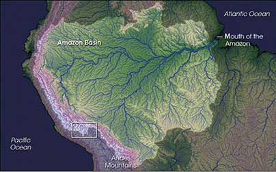
At the core of the continent is the mighty Amazon River, which is more than 4,300 miles long and has an enormous drainage basin in the largest tropical rain forest in the world. The Amazon’s many tributaries are larger than many other world rivers. The Amazon and its many tributaries drain the entire interior region of the continent, covering 40 percent of South America. The Amazon has the greatest discharge of any river in the world, carrying about one fifth of all river water on the planet, and is probably the longest river in the world (only the Nile River may be longer, depending on how the exact length is measured). During the rainy season, the Amazon River can be more than one hundred miles wide. No bridges span the Amazon River. Its source is a glacial stream located high in the Peruvian Andes, only about 150 miles from the Pacific Ocean.
The Amazon’s extended tributaries—such as the Rio Negro, the Madeira, and the Xingu—move massive amounts of water through the Amazon Basin and are major rivers in their own right. The Amazon has more than 1,100 tributaries; a dozen are more than one thousand miles long. Hydroelectric dams are located on the tributaries to produce electricity for the region’s fast-growing development. South America has additional large rivers that drain the continent, including the Orinoco, which flows through Venezuela; the Sao Francisco, which flows through southeast Brazil; and the Paraguay and the Paraná Rivers, which flow south from Brazil into the Rio de la Plata between Argentina and Uruguay.
The Altiplano Region is a wide basin between two main Andean mountain ranges. The word altiplano means “valley” in Spanish. There are a substantial number of altiplanos in South America. They provide for agricultural production and human habitation. Lake Titicaca rests in the middle of the Altiplano Region of the Central Andes on the border between Peru and Bolivia. Lake Titicaca is a large freshwater lake about 120 miles long and 50 miles wide. The surface is at an elevation of about twelve thousand feet above sea level, and the lake is more than nine hundred feet deep in some areas. Usually at such high elevations, the temperature would dip below freezing and restrict agriculture. However, the large lake acts as a solar energy collector by absorbing energy from the sun during the day and giving off that energy in the form of heat during the night. The energy redistribution allows for a moderate temperature around the lake that is conducive to growing crops. With abundant fresh water and the ability to grow food and catch fish, the Altiplano Region has supported human habitation for thousands of years.
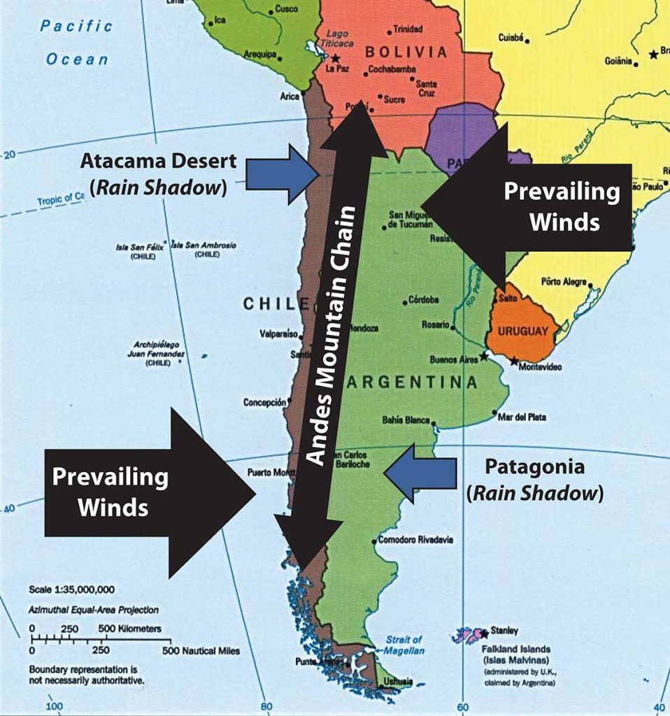
Across the Andes Mountains from the Altiplano Region is the Atacama Desert. The Atacama is one of the driest places on Earth: in some parts, no rain has fallen in recorded history. In normal circumstances, the Atacama would be a desolate region without human activity, but that is not the case. Some of the world’s largest copper reserves are found here. Nitrates, which are used in fertilizers, are also found in large quantities. Mining the Atacama has brought enormous wealth to people fortunate enough to be on the receiving end of the profits. The rain shadow effect is responsible for the extraordinary dryness of the Atacama. The Andes are quite high at this latitude, and the winds blow in rain clouds from the east. When the clouds reach the mountains, they ascend in elevation, releasing their precipitation without ever reaching the western side of the Andes.
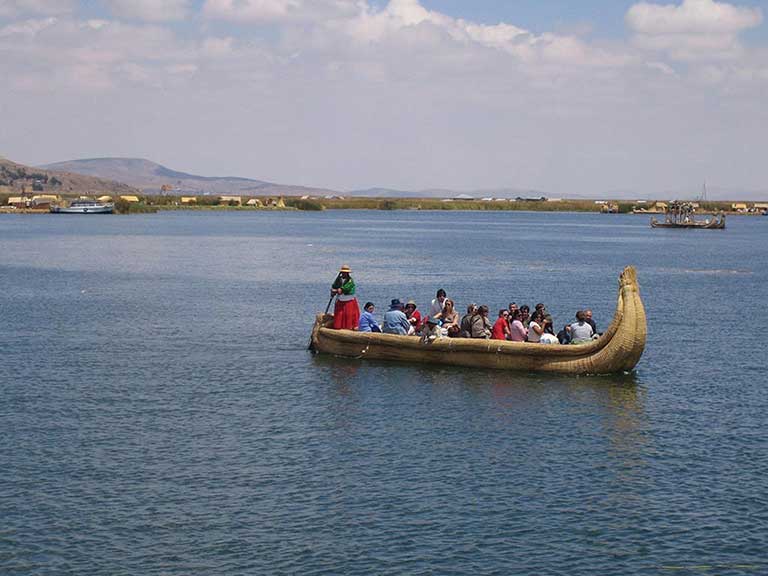
locals. Lake Titicaca is the highest-elevation navigable lake in the world.
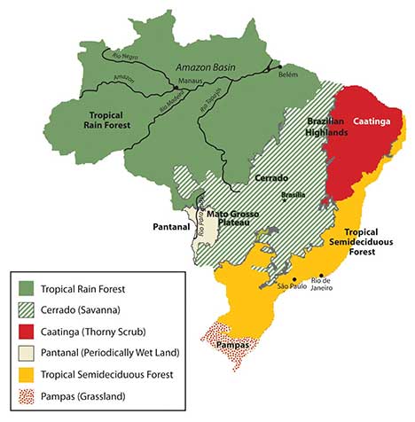
South America has large agricultural plateaus east of the Andes, such as the Mato Grosso Plateau, which includes a portion of the great Cerrado agricultural region of central Brazil. The Cerrado is a vast plain that has been developed for agriculture and produces enormous harvests of soybeans and grain crops. Bordering the Cerrado to the southeast are the Brazilian Highlands, an extensive coffee-growing region. The Pampas in eastern Argentina, Uruguay, and southernmost Brazil is another excellent agricultural region with good soils and adequate rainfall. Farming, cattle ranching, and even vineyards can be found here, making the Pampas the breadbasket of the Southern Cone. To the south of the Pampas is the lengthy expanse of Patagonia, which covers the southern portion of Argentina east of the Andes. Patagonia is a prairie grassland region that does not receive much rainfall because of the rain shadow effect of the Andes to the west. The main activities in Patagonia are the raising of cattle and other livestock. The region is starting to attract attention for the extraction of natural resources such as oil, natural gas, and valuable minerals.
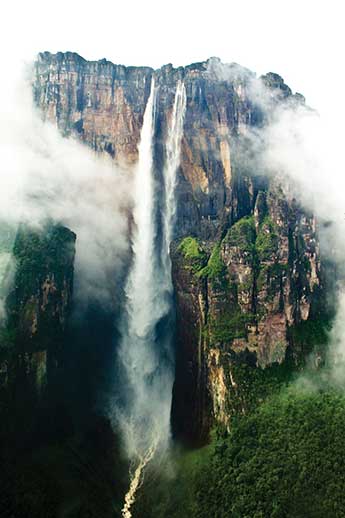
To the northern part of the continent in Venezuela and Colombia, sandwiched between the Andes Mountains and the Guiana Highlands, is a grassland region with scrub forests called the Llanos. The human population is small because of the remoteness of the region along the Orinoco River basin. The Guiana Highlands of southeast Venezuela and the Guianas are an isolated set of mountainous plateaus mixed with rugged landscapes and tropical climates. Angel Falls, the highest waterfall in the world, with a free fall of more than 2,647 feet and a total drop of about 3,212 feet (more than half a mile), is located here. To the northwest of the Llanos and the Guiana Highlands in Venezuela is Lake Maracaibo, a large inland lake open to the Caribbean Sea. A coastal lake, Maracaibo rests atop vast oil reserves that provide economic wealth for Venezuela.
B. European Colonialism
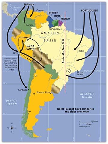
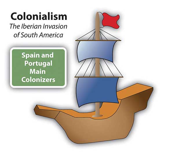
South America’s colonial legacy shaped its early cultural landscape. The indigenous people, with their empires and local groups, were no match for the Iberian invaders who brought European colonialism to the continent. South America was colonized exclusively by two main Iberian powers: Spain colonized the western part of the South America, and Portugal colonized the east coast of what is present-day Brazil. The only region that was not colonized by those two powers was the small region of the Guianas, which was colonized by Great Britain, the Netherlands, and France.
Everything changed with the invasion of the Iberian colonizers. The underlying tenets of culture, religion, and economics of the local indigenous people were disrupted and forced to change. It is no mystery why the two dominant languages of South America are Spanish and Portuguese and why Roman Catholicism is the realm’s dominant religion. Colonialism also was responsible for transporting food crops such as the potato, which originated in the Peruvian Andes, to the European dinner table. Today, coffee is a main export of Colombia, Brazil, and other countries in the tropics. Coffee was not native to South America but originated in Ethiopia and was transferred by colonial activity. The same is true of sugarcane, bananas, and citrus fruits; oranges were not native to South America, but today Brazil is the number one exporter of orange juice. Colonialism was driven by the desire for profit from the quick sale of products such as gold or silver, and there was a ready market for goods not found in Europe, such as tobacco, corn, exotic animals, and tropical woods.
South America were Spain and Portugal. The Spanish conquistador
Francisco Pizarro defeated the Inca Empire.
Plantation agriculture introduced by the Europeans led to a high demand for manual laborers. When the local populations could not meet the labor demand, millions of African workers were brought through the slave trade. These African slaves introduced their own unique customs and traditions, altering the culture and demographics of the Western Hemisphere. The current indigenous Amerindian population, a fraction of what it was before the Europeans arrived, makes up only a small percentage of South America’s total population. Europeans colonizers generally took the best land and controlled the economic trade of the region. The acculturation in South America is directly related to the European colonial experience.
C. The Inca Empire and Francisco Pizarro
Not long after Hernán Cortés conquered the Aztec Empire of Mexico in 1521, a young Spanish conquistador named Francisco Pizarro, stationed in what is now Panama, heard rumors of silver and gold found among the South American people. He led several sailing excursions along the west coast of South America. In 1531, he founded the port city of Lima, Peru. Since 1200, the Inca had ruled a large empire extending out from central Peru, which included the high-elevation Altiplano Region around Lake Titicaca. The Inca Empire dominated an area from Ecuador to Northern Chile. The Inca were not the most populous people but were a ruling class who controlled other subjugated groups. Pizarro, with fewer than two hundred men and two dozen horses, met up with the Inca armies and managed to defeat them in a series of military maneuvers. The Inca leader was captured by the Spanish in 1533. Two years later, in 1535, the Inca Empire collapsed.
The Inca Empire was significant thanks to the high volume of gold and silver found in that region of the Andes. The mineral wealth of the Andes made the conquistadors rich. Lima was once one of the wealthiest cities in the world. Europeans continued to dominate and exploit the mining of minerals in Peru and Bolivia throughout the colonial era. European elites or a Mestizo ruling class has dominated or controlled the local Amerindian groups in the Andes since colonial times.
D. The Iberian Division of the Continent
The Spanish conquistadors were not the only European invaders to colonize South America. Colonial influence—which forced a change in languages, religion, and economics—also came from the small European kingdom of Portugal. Portuguese ships sailed along the eastern coast of South America and laid claim to the region for the king. The Portuguese did not find large gold or silver reserves, but they coveted the land for the expansion of their empire. Soon the Spanish and the Portuguese were fighting over the same parts of South America. In 1494, the issue was brought before the Roman Catholic Church. The Tordesillas Line was drawn on a map to divide South America into the Spanish west and the Portuguese east. The region that is now Brazil became the largest Portuguese colonial possession in South America, a center for plantation agriculture similar to that in the Caribbean. For this reason, a large African population lives in Brazil, and most of the people in Brazil speak Portuguese and are Roman Catholics.
Independence did not come for the Spanish colonies until 1816 and 1818, when Chile and Argentina broke away in an independence movement in the south. Simón Bolívar led liberation movements in the north. By 1824, the Spanish were defeated in South America. Brazil did not gain independence from Portugal until 1822, when the prince of Portugal declared an independent Brazil and made himself Brazil’s first emperor. It was not until 1889 that a true republic was declared and empire was abolished.
E. Cultural Regions of South America
It is impossible to understand the current conditions in South America without first understanding what occurred to create those conditions. This is why studying European colonialism is so important. Colonialism changed the ethnicity, religion, language, and economic activities of the people in South America. The past five hundred years have tempered, stretched, and molded the current states and regions of the South American continent. To identify standards of living, ethnic majorities, and economic conditions, it is helpful to map out South America’s various cultural regions.
In South America, five main cultural regions indicate the majority ethnic groups and the main economic activities: Tropical Plantation Region, Rural Amerindian Region, Amazon Basin, Mixed Mestizo Region, and European Commercial Region (Southern Cone).
These are generalized regions that provide a basic understanding of the whole continent. Technological advancements and globalization have increased the integration of the continent to the point that these regions are not as delineated as they once were, but they still provide a context in which to comprehend the ethnic and cultural differences that exist within the realm.
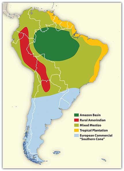
Tropical Plantation Region
Located along the north and east coast of South America, the Tropical Plantation Region resembles the Caribbean rimland in its culture and economic activity. The region, which extends as far south as the Tropic of Capricorn, has a tropical climate and an agricultural economy. Europeans opened up this area for plantation agriculture because of coastal access for ships and trade. The local people were forced into slavery, but when the local people died off or escaped, millions of African slaves were brought in to replace them. After slavery was abolished, indentured servants from Asia were brought to the Guianas to work the plantations. The Tropical Plantation Region has a high percentage of people of African or Asian descent.

Rural Amerindian Region
The Rural Amerindian Region includes the countries of Ecuador, Peru, and Bolivia. The ruling Mestizo class that inherited control from the European conquistadors mainly lives in urban areas. Most of the rural Amerindian population lives in mountainous areas with type H climates and ekes out a hard living in subsistence agriculture. This is one of the poorest regions of South America, and land and politics are controlled by powerful elites. The extraction of gold and silver has not benefited the local Amerindian majority, which holds to local customs and speaks local languages.
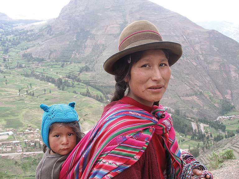
photo live in the Sacred Valley of the Andes in Peru.
Amazon Basin
The Amazon Basin, which is characterized by a type A climate, is the least-densely populated region of South America and is home to isolated Amerindian groups. Development has encroached upon the region in the forms of deforestation, mining, and cattle ranching. Large deposits of iron ore, along with gold and other minerals, have been found in the Amazon Basin. Preservation of the tropical rain forest of this remote region has been hampered by the destructive pattern of development that has pushed into the region. The future of the basin is unclear because of development patterns that are expected to continue as Brazil seeks to exploit its interior peripheral region. Conflicts over land claims and the autonomy of Amerindian groups are on the rise.
Mixed Mestizo Region
The Mixed Mestizo Region includes the coastal area of the west and the interior highlands of the north and east. This region between the Tropical Plantation Region and the Rural Amerindian Region includes a majority of people who share a mixed European and Amerindian ethnicity. It is not as poor as the Rural Amerindian Region and yet not as wealthy as the European-dominated region to the south. Paraguay falls into the Mixed Mestizo Region, as do other portions of other South American countries such as parts of Brazil, Colombia, and Venezuela. Paraguay is mainly Mestizo, but its economic qualities resemble that of the Rural Amerindian Region to the north, even though Paraguay is not located in the mountains.
European Commercial Region (Southern Cone)
The southern part of South America, called the European Commercial Region or the Southern Cone, includes Chile, Argentina, Uruguay, and parts of Brazil. European ethnic groups dominate this region and include not only Spanish and Portuguese but also German, Austrian, Italian, and other European ethnic heritages. Fertile soils and European trade provided early economic growth, and the region attracted industry and manufacturing in the later decades of the twentieth century. There are not many Amerindians or people of African descent here. More than 90 percent of all the people in Argentina, Chile, and Uruguay are of European descent and live in urban areas. With a highly urbanized population and with trade connections to a globalized economy, it is no surprise that the Southern Cone is home to South America’s most developed economies.
F. Globalization and Trade
South America has been fragmented by European colonialism, which established colonies and economic dependence on its European masters. The colonial economic patterns did not encourage the South American countries to work together to create an integrated continental trade network. Countries outside the continent have promoted trade partnerships to benefit from South America’s natural resources and agricultural exports. The establishment of the European Union and the North American Free Trade Agreement (NAFTA) created globalized trading blocs that challenged the South American countries to consider how to take advantage of trading opportunities within their realm to protect and support their own economic interests.
Since the 1990s, cooperation and business ventures have started to form within the realm to create a more integrated network of trade and commerce to benefit the countries of South America. Transportation and communication systems are being developed through joint ventures by internal investment groups. River and road systems continue to be managed and developed for improved transport of people and goods throughout the continent. Free-trade agreements have been implemented to support the integration of internal economic networks and competition in the global marketplace.
In 2008, the South American countries formed the Union of South American Nations (UNASUR) to oversee the customs unions and trade agreements within the realm. One of the more established trade associations is Mercosur (the Southern Cone Common Market), created in 1995 by the southern countries. It has evolved to include most countries in South America and is the most dominant trade agreement in the realm. Full members of Mercosur include Argentina, Uruguay, Paraguay, Brazil, and Venezuela (although Venezuela’s membership was suspended in late 2016). Chile, Bolivia, Peru, Ecuador, and Colombia are associate members. The Andean Community (Colombia, Ecuador, Peru, and Bolivia) was established in 1969 but did not gain ground until 1995, when it established stronger trade measures. Multinational corporations have supported the creation of a Free Trade Area of the Americas (FTAA) to include all of the Western Hemisphere in one unified trade association. It has not been approved and has received strong opposition from Mercosur and economic forces that support a more localized economy controlled by local people.
South America faced division and competition during the colonial era between the Spanish and the Portuguese. Today’s new era of corporate colonialism has created similar fragmentation and divisions. The level of trade between the countries of South America and the United States and Europe varies widely. Countries such as Colombia and Chile have well-established trade relationships with the United States and are unwilling to jeopardize those trade connections to strengthen ties with their neighbors that have less-supportive political relationships with the United States. External global trade arrangements often provide financial benefits to individual countries that might not be shared by the bordering countries in the same region. South America’s historical fragmentation has not made it easy to unify the continent under a singular trade agreement to complete against the European Union or NAFTA.
Key Takeaways
- The extensive Andes Mountain chain and the massive Amazon River dominate the realm’s
physical geography. - The Spanish and the Portuguese were the two main colonial powers that dominated South America. The Guianas were the only part of the continent not dominated by these two European powers.
- Identifying the majority ethnic groups in South America can be helpful in classifying the various cultural regions of the realm. Colonial activities and ethnic backgrounds are consistent enough to formulate regions with similar characteristics.
- Globalization and the creation of economic or political units such as the European Union and NAFTA have prompted the South American countries to work together to implement cooperative trade agreements and create the Union of South American Nations.
8.2 Urban North and Andean West
Learning Objectives
- Understand the dynamics of Venezuela’s urban society and why Venezuela has not experienced a robust rural-to-urban shift to the extent that other countries have.
- Summarize the production of the three main export products of Colombia and explain the US role in their export.
- Compare the three main countries in the Andean West region of South America and understand how they gained their wealth and who has benefited the most over the years from that wealth.
- Outline how Paraguay’s geographical setting has allowed it to gain wealth and provide opportunities for its people.
A. Venezuela: Oil, Politics, and Globalization
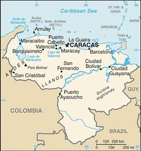
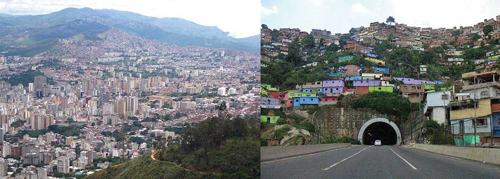
Bordering the Caribbean is the large urban country of Venezuela. The Andes Mountains reach into the northern part of the country and make up the terrain of the northern coastal region all the way to the capital city of Caracas. The large grassland plains of the Llanos extend farther south from the Colombian border to the Orinoco River delta. The Llanos is a large, sparsely populated region that makes up about one-third of the country. It is remote, susceptible to flooding, and used mainly for raising cattle. In the southeast of Venezuela are the Guiana Highlands, which make for a spectacular physical landscape of tropical forests and rugged mountainous terrain. The highlands include Angel Falls, the tallest waterfall in the world. Angel Falls drops 2,647 feet and is Venezuela’s most popular tourist attraction. Lake Maracaibo, a large inland sea located in the western region of the country, is not a true lake in that it is open to the Caribbean Sea, but it is considered the largest inland body of water in South America. Lake Titicaca, located in the Andean region of the Altiplano on the border between Peru and Bolivia, is considered the continent’s largest freshwater lake.
Venezuela has an assortment of physical regions, but most of the population lives along the northern coast. About 90 percent live in urban areas, and the capital Caracas has the highest population. Less than 5 percent of the population lives south of the Orinoco River, and Amerindian groups live in the interior and along the river.
Included in the Mixed Mestizo Cultural Region, Venezuela has a heavy Spanish influence laid over an Amerindian base in a plantation region known for its African infusion. There is also a strong Caribbean cultural flavor, which is evident in the region’s music and lifestyle. The official language is Spanish, but more than thirty indigenous languages are still spoken in the country.
As much as 90 percent of Venezuela’s export earnings are from the export of oil. Venezuela’s national oil company, CITGO, has made extensive inroads into the US gas station market. The country was one of the founding members of OPEC (Organization of Petroleum Exporting Countries), which is usually associated with the oil-rich states of the Persian Gulf. In the past decade, Venezuela has been one of the top five countries exporting oil to the United States. The other four are Canada, Mexico, Saudi Arabia, and Nigeria.
The country’s enormous oil revenues and its current political climate have increased Venezuela’s visibility in the global arena, but how this will play out over the long term is unclear. In the past, Latin America has had a greater number of elected political leaders with more progressive or socialist views. These trends continue to shape the economic trade agreements between countries. Venezuela has been working to increase sales of oil to countries in Mercosur (the Southern Cone Common Market), which is the most significant trade association in South America.
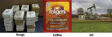
B. Colombia: Drugs, Coffee, and Oil
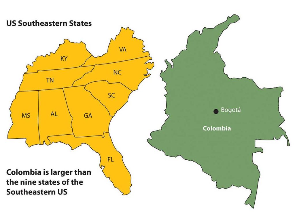
Three ranges of the Andes Mountains run from north to south through Colombia, which is larger than the nine most southeastern US states. With a land area covering about 440,839 square miles, Colombia is more than four times the size of the US state of Oregon and close to twice the size of France. Colombia borders five countries, with the Caribbean to the north, the Pacific Ocean to the west, the Orinoco River to the east, and a short segment of the Amazon River to the far south. Even though agriculture has been a mainstay of the country’s economic activities, because of the influence of the mountainous terrain, about 75 percent of the population lives in urban areas.
Colombia and the Drug Trade
Colombia’s tropical climate and its many remote areas contributed to its development as a major coca-growing region. By the 1970s, extensive drug smuggling had developed, and powerful drug cartels became major political brokers within the country, competing against the government for control of Colombia. The largest and most organized cartels operated out of Medellin and Cali, the second- and third-largest cities in the country after the capital city of Bogotá.
The coca plant grows throughout the slopes of the Andes, from Colombia to Bolivia. Historically, locals have chewed it or brewed it into tea. Coca can alleviate elevation sickness and act as a mild stimulant. Using modern methods and strong chemicals, the coca leaves can be converted into coca paste and then into cocaine, a powerful narcotic. (It must be noted that the short, leafy coca plant that cocaine comes from is not the same as the cacao tree that produces the beans that chocolate or cocoa comes from. They are two completely different plants with separate processes.)
The United States is the largest cocaine market. Secret airfields and private boats transport the cocaine from Colombia to distribution centers in Mexico, Central America, or the Caribbean. From there, the drugs are smuggled into the United States. Colombian drugs are a multibillion-dollar industry that makes up a large portion of the Colombian economy. The effect of the drug industry on the people of Colombia is extensive—from the gunfire on the streets to the corruption of government officials. In recent years, the same drug cartels that have operated the cocaine industry have imported opium poppies, which grow well on the higher and more arid slopes of the Andes. Opium poppies are native to Asia but have been transported to South America. Opium is extracted from the seedpod and can be further refined into heroin. Colombian drug cartels, with a Mexican distribution network, have muscled into as much as 20 percent of the US heroin market. The US government has supported the Colombian government in the fight against the drug cartels and the trafficking of illegal drugs out of Colombia.
Colombian Coffee and Oil
Colombia’s two main legal exports to the United States are coffee and oil. Coffee is only grown in the tropics, since coffee trees must be grown in a frost-free environment. Coffee trees can grow in elevations from sea level to six thousand feet, but most of the best specialty coffee is grown at elevations of three thousand to six thousand feet. Colombia has ideal conditions for growing coffee and was once the world’s largest coffee producer; now Brazil and Vietnam each produce more.
Oil has now become Colombia’s number one legal export. Oil is found in fields in the northern and central regions of Colombia. Immense quantities of coal are also found in the same regions, but oil is more valued on the export market. Pipelines connect the interior oil fields of Colombia with the northern ports. The US market size and population make it the world’s largest oil consumer. US oil companies have been investing in the development of Colombian oil for many years. Colombia has been a developing oil source even though its total extractable resources are not as vast as in other countries. For example, in 2006 the United States imported more oil from Colombia than from Kuwait, Oman, the United Arab Emirates (UAE), Bahrain, Qatar, and Yemen combined.
The relationship between Colombia and the United States is often conflicting. The US consumer supports the Colombian drug cartels by being the largest consumer of illegal drugs. The US government, under the Drug Enforcement Administration (DEA), has declared a war on drugs and has supported the Colombian government with billions of dollars in foreign aid to fight that war. On another front, US oil corporations have paid insurgent groups to protect their oil assets. Oil is exported to the United States, bringing billions of dollars into the Colombian economy. The chaos in Colombia is directly related to the exploitation and marketing of their resources. It is the people of Colombia that suffer in the cross fire from this civil war of corruption, crime, death, and destruction. The United States is a counterforce partner in this situation but operates from the consumer end of the resource pipeline. The largest consumer market for Colombia’s export of oil, drugs, and coffee is the United States, which is also the largest contributor of foreign aid
to Colombia.
C. Rural Amerindian States of Ecuador, Peru, and Bolivia
The Central Andes, which includes Ecuador, Peru, and Bolivia, were home to the Inca Empire. The empire had gone through some internal divisions and was working on unifying the region when Francisco Pizarro’s small army defeated the Incan warriors and brought about colonial rule beginning in the 1530s. Many cultures lived in the Central Andes before the Inca, and their legacy continues in the customs and the ways of the Amerindian people who still live there today. Spanish is the official language, or the lingua franca, but indigenous languages are widely spoken and dominate in the rural areas and remote villages. Ecuador, Peru, and Bolivia make up the core of the Rural Amerindian Region of South America. There have been border disputes among the three countries, and also with their neighbors. Nevertheless, they all share the Andes and have many things in common.
Physical Geography
The physical geography of the Central Andes includes more than just the high Andes Mountains, although they dominate the landscape. The coastal region to the west of the Andes is generally warmer than the cooler climate of the mountains. The equatorial region is rather humid. The coastal region in southern Peru is dry and arid because of the ocean currents and the rain shadow effect of the Andes, which creates the Atacama Desert that extends up from northern Chile. Southwest Bolivia has some of the world’s largest salt flats in this dry and barren region. In the interior, on the eastern side of the mountain ranges, is the huge expanse of the Amazon Basin. Tropical and humid with heavy precipitation is generally the climate rule. Rain forests and jungle fauna can be found on the eastern slopes. The Altiplano region has the high-elevation Lake Titicaca. The variations in physical terrain provide extensive biodiversity in animal and plant species. It also supports a variety of economic activities to exploit the bountiful natural resources.
Even though the Altiplano region borders the Pacific Ocean, it also links directly to the Atlantic Ocean. The headwaters that create the Amazon River start in Peru, and by the time the water reaches the Peruvian city of Iquitos, the river is large enough to accommodate large shipping vessels. Iquitos is a port city for the Atlantic Ocean with access to Europe, Africa, or eastern North America. The port also links the region with Brazil’s free-trade zone in Manaus, which has access to large oceangoing shipping and an international market.
Economic Geography
The region’s main income comes from exports of minerals, fossil fuels, and agricultural products. Oil is the number one means of gaining national wealth in Ecuador and Peru; natural gas is the number one export of Bolivia. Gold, silver, tin, and other minerals are also abundant.
Poverty and the exploitation of natural resources usually result in environmental degradation unless proper measures are taken to prevent it. The area’s heavy reliance on oil and gas extraction to gain national wealth has come at a great cost to their environment. Many oil spills have caused oil to enter the freshwater supplies of local residents and pollute the rivers and streams of the Amazon Basin. Mining has traditionally devastated the land because large portions of earth are removed to extract the ore or mineral. Pollution is causing a loss of habitats and destroying ecosystems, and few measures are being taken to prevent it. Deforestation is being caused by the timber industry and by clearing for agriculture. Overgrazing and the removal of the trees leave the soil open to erosion.
Tourism
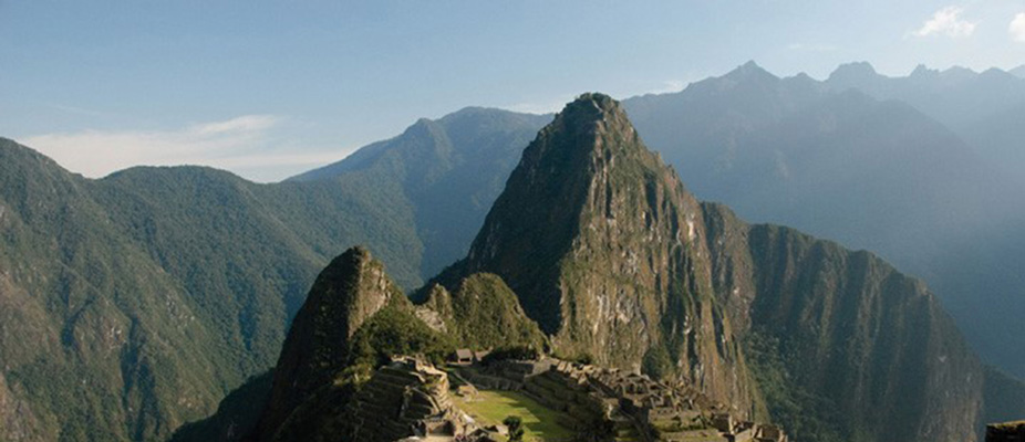
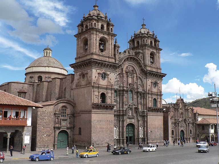
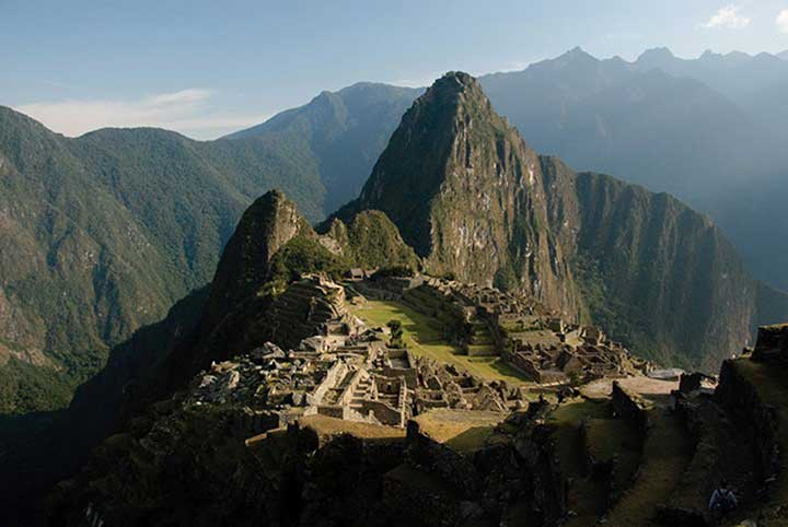
Tourism is expanding to connect travelers with opportunities to explore Incan and pre-Incan sites, which are the main attractions. One of the main tourist attractions in Peru is the ancient city of Machu Picchu in the Andes not far from Cuzco. In 2010, Peru gained over two billion dollars from the tourist activities of about two million foreign tourists. Ecuador’s major tourist attraction is the Galapagos Islands, which aided Charles Darwin in understanding natural selection and the evolutionary process. Bolivia has a number of ancient sites that predate the Inca and have become major tourism destinations. The ancient city of Tiahuanaco and the enigmatic Lake Titicaca are good examples.
Tourism can be a great source of economic income but it can come at a cost to the environment. There is always concern that high-traffic tourism sites like Machu Picchu can be degraded by the sheer mass of people visiting the site. The environmental imprint may be extensive. The term ecotourism has been used to indicate the activity of people traveling to experience and enjoy the natural world with an aim not to damage the environment in the process. The main objective was to make the tourism activity sustainable, which promoted stewardship of the land and respect for its attractions. Jonathan Tourtellot, director of the National Geographic Society’s Center for Sustainable Destinations, coined and prefers the term geotourism, which can be translated as the stewardship of place and the preservation of its essential character. These concepts are becoming more integrated with the tourism industry to promote a sustainable model for high traffic sites like the Galapagos Islands with fragile ecosystems.
Population and Culture
Population growth is a major factor in the future of Peru, Ecuador, and Bolivia. In 2010, Bolivia had more than ten million people, Ecuador had more than fourteen million, and Peru had about twenty-nine million. More than 30 percent of the population of Ecuador and Bolivia resides in rural areas and make a living from subsistence agriculture. All three countries have large populations in relation to the production of adequate food. Peru and Bolivia are large countries in physical area but do not have a high percentage of arable land. Rural-to-urban shift is increasing and the major cities are continuing to expand, overtaxing public works and social services.
The culture of the Central Andes is heavily influenced by its rural Amerindian heritage. The foundation of the traditional agrarian society has been subsistence agriculture. One-third of the population in Ecuador and Bolivia and up to one-fourth of the population in Peru continue to live a traditional way of life. Local cuisine reflects the connection to the land. Potatoes, maize, guinea pigs, and fish are common fare in rural areas. The cities are encountering international influences that are changing the demands in local cuisine and culture. Traditional food, arts, and local crafts still thrive in the local districts and for the tourism market.
Key Takeaways
- Most of the people in Venezuela live in cities along the Caribbean coast. The country has always been urban and has not developed its agricultural production. Venezuela depends on oil exports to gain most of its national wealth.
- The United States is the largest consumer of products exported from Colombia. Illegal drugs, oil, and coffee and are the three main export products of Colombia. The United States directly or indirectly supports the three main factions vying for power within Colombia.
- The Andean countries of Ecuador, Peru, and Bolivia share similar developmental dynamics, including a large percentage of Amerindian people and reliance on the export of natural resources to gain national wealth. The wealth gained from exports is concentrated in the hands of elites rather than filtering down to most of the people.
8.3 Brazil
Learning Objectives
- Summarize the ethnic composition of Brazil and learn why the population is so diverse.
- Explain how the core-periphery spatial relationship applies to the country. Be able to clarify how the dynamics of the country shape the core and the periphery.
- Describe the main activities that are involved in the development and exploitation of the Amazon Basin. Learn how deforestation affects the tropical rain forest and environmental conditions.
- Outline the main characteristics and economic activities of the main regions of Brazil.
A. Portuguese Colony
Brazil, the largest country in South America, is similar in physical area to the contiguous United States (the United States without Alaska or Hawaii). Catholicism is the dominant religion and Portuguese is the primary language. Once a Portuguese colony, the country’s culture was built on European immigration and African slave labor, making for a rich mixture of ethnic backgrounds.
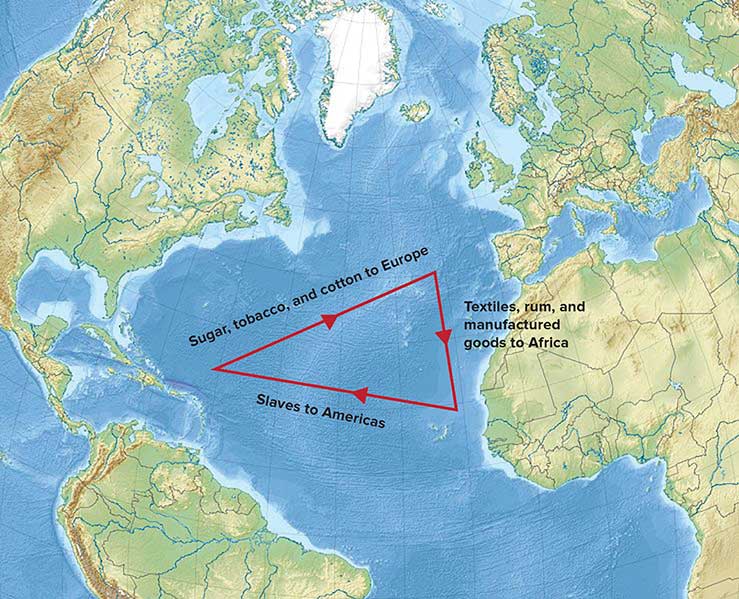
In colonial times, Brazil was a part of the Atlantic Trade Triangle, which functioned as a transportation conveyor, moving goods and people around the regions bordering the Atlantic Ocean. Colonial merchant ships financed by Europe’s wealthy elite brought goods and trinkets to the African coast to trade for slaves, who were shipped to the Americas and the Caribbean to diminish the labor shortage for the colonies. The last leg of the Atlantic Trade Triangle moved food crops, sugar, tobacco, and rum from the colonies back to the European ports. The merchant ships never sailed with an empty hold, and their successful voyages provided enormous profits to the European financiers.
The total number of individuals taken as slaves from Africa is unclear and often debated. It is estimated that more than ten million African slaves survived the Middle Passage from Africa to the Western Hemisphere, which is more than the current population of Bolivia. Slavery supplied cheap labor for the plantations and agricultural operations in the New World. Brazil took in more African slaves than any other single country—at least three million. Colonial Brazil thrived on early plantation agriculture. When slavery was abolished in Brazil in 1888, the freed slaves found themselves on the lower end of the socioeconomic hierarchy. People of mixed African descent now make up more than one-third of Brazil’s population. The Afro-Brazilian heritage remains strong and dominates the country’s east coast. The African influence is evident in everything from the samba schools of the Brazilian carnival to the music and traditions of the people. In spite of Brazil being a culturally diverse country, Africans still have not found themselves on an even playing field in terms of economic or political opportunities in positions of power in the country.
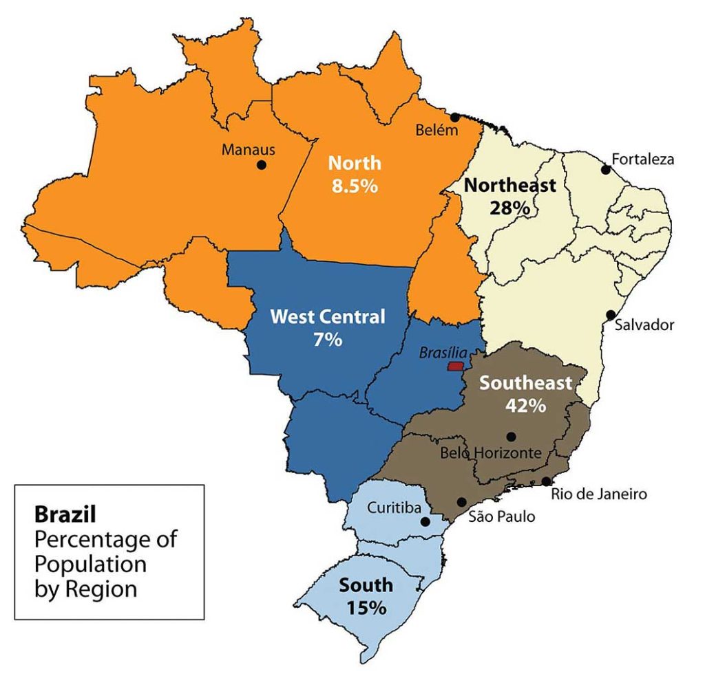
B. Southeast Core: Urban and Industrial
Brazil’s human development patterns are an example of the core-periphery spatial relationship. The main economic core area is located in the southeast region of Brazil, an area that is home to the largest cities of the realm and acts as the hub for industrial and economic activities. Political and economic power is held by elites residing in the urban core areas. The rural northern Amazon Basin is the heart of the periphery, providing raw materials and resources needed in the core. The periphery has a small population density, and most are Amerindian groups that make a living from subsistence agriculture, mining, and forestry. Rural-to-urban shift has prompted many of the rural poor to migrate to the large cities.
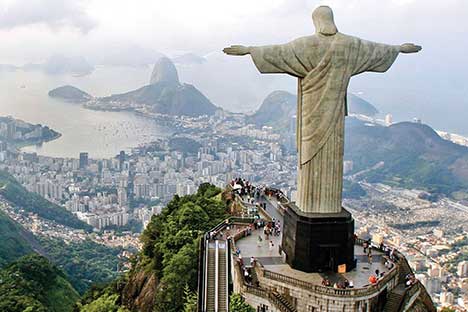
Founded in 1554 as a Catholic mission, the city of São Paulo rests at the heart of the core region. Its pattern of development is similar to that of Mexico City. Coffee production was the early basis of the local economy. São Paulo is located about thirty miles inland from the coast. It has grown to be the center of trade and industry for Brazil, but Rio de Janeiro receives greater attention for tourism. With more than twenty million people, São Paulo is the largest industrial metropolis south of the Equator, the largest city in South America, and among the largest cities on the planet.
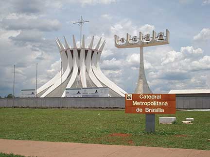
Rio de Janeiro, Brazil’s best-known city, is a travel and international business center with a population of more than ten million. The city is renowned for its carnival festivities and famous coastline. Tourists are attracted by its cultural attractions and coastal setting, with beautiful sandy beaches and the landmark Sugarloaf Mountain located in an open bay. Salvador, located on the coast, was Brazil’s first capital. Rio de Janeiro became the capital in 1763, but to further develop Brazil’s interior, in 1960 the capital was moved from Rio to the forward capital of Brasilia. Forward capitals are created to either shift development or to safeguard a geographical region. Brazil has an enormous interior region that it wishes to continue to develop for economic gain and the creation of the forward capital of Brasilia is in line with this objective.
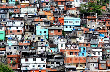
The three cities of São Paulo, Rio de Janeiro, and Brasilia, along with their urban neighbors, anchor the core region in the south. Brazil’s internal migration to these cities follows a rural-to-urban or periphery-to-core pattern, and these three cities continue to grow at an unprecedented rate. São Paulo is more than sixty miles across. As migrant workers from the countryside and from the rural northeast migrate to the cities looking for work, they expand the city through self-construction. Slums, called favelas, extend out from the central city for miles.
The cultural fabric of Brazil has been built by immigrants from many countries. Brazil’s diverse population has linked the country to the homelands of its immigrants and established trade and cultural connections that benefit the country in the global marketplace. The more than two hundred million people that make up Brazil’s population are diverse and yet integrated, even if many still hold to the traditions or cultural heritage of their country of origin. After World War II, a large number of Japanese migrated to São Paulo. Today, Brazil boasts the largest Japanese population outside Japan. Many people from both Western and Eastern Europe have made Brazil their home, and large numbers of people from Lebanon, Syria, and the Middle East have immigrated here.
In spite its cultural diversity, Brazil has two overarching cultural forces that have helped hold the country together: the Portuguese language and Catholicism. These two centripetal forces help establish a sense of nationalism and identity. The Portuguese language has been adapted to the Brazilian society to reflect a slightly different dialect than the Portuguese spoken in Portugal. The Portuguese language has more of a unifying effect than religion. Though about 70 percent of the population claims to be Roman Catholic, additional religious affiliations in Brazil range from the African influence of Umbanda to the Muslim minority. Protestant denominations are the second-largest religious affiliations in Brazil. Secularism is on the rise, and many do not actively practice their specified religion.
In both population and physical area, Brazil ranks fifth in the world. Brazil is as urban as the United States or countries in the European Union. Average family size has dropped significantly, from 4.4 children in 1980 to 2.4 children in 2000, and continues to decline. Religious traditions give way to the urban culture and secular attitudes of modernity when it comes to family size.
Approximately 87 percent of Brazil’s population lives in urban areas. Urbanization seldom eliminates poverty. Though the index of economic development indicates that urbanization will increase incomes for the population as a whole, poverty is a standard component of any large urban area in most places of the world, and the favelas of Brazil are similar to slums elsewhere.
The favelas of Brazil’s urban centers are dynamic places, where land ownership, law and order, and public services are questionable. Millions of people live in the favelas of Brazil’s large cities. Poverty and the search for opportunities and advantages are common elements of urban life. The core cities of Brazil suffer from the same problems as other developing megacities: overcrowding, pollution, congestion, traffic jams, crime, and increased social tensions. The energy generated by the sheer magnitude of people, industry, and commerce continues to fuel Brazil’s vibrant growth and its many large, dynamic cities.
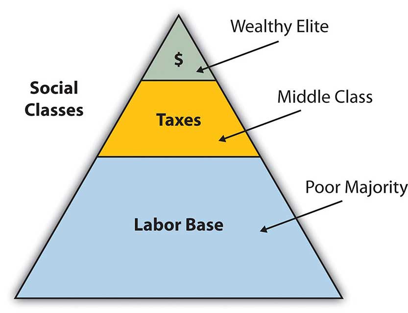
The pattern of wealth developing in Brazil is quite common: wealth and the ability to obtain wealth are held in the hands of those at the higher end of the socioeconomic ladder. The pyramid-shaped graphic used to illustrate Mexico’s social layers in the chapter on Middle America can also be applied to Brazil. The minority wealthy elite own most of the land and businesses and control more than half the wealth. Corporate colonialism is quite active in Brazil. Multinational corporations take advantage of the country’s development activities and muscle in on the profits, which seldom reach the hands of the majority at the lower end of society.
Brazil economically dominates and anchors South America and is an emerging power in the world marketplace. Brazil has the largest economy in South America and is a parallel force with the United States in the Northern Hemisphere. The country has urbanized and industrialized to compete with the global economic core areas in many ways. Brazil is among the ten largest economies in the world.
Brazil has favorable resources and labor to complete in the global marketplace. Its agricultural output has grown immensely over the past few decades. Brazil is a major exporter of soybeans, coffee, orange juice, beef, and other agricultural products. Brazil is the largest coffee producer in South America, but coffee only constitutes about 5 percent of its current annual exports. Coffee production is extensive in the Brazilian Highlands just inland from the coast. In addition, Brazil exports more orange juice than any other country and is second in the world in soybean production. The vast central interior regions such as the cerrado continue to be developed for industrial farming of massive food crops. However, exports of industrial manufactured products surpassed agricultural exports in 2010.
The availability of abundant minerals and iron ore has supported an expanding steel industry and automotive manufacturing, and its industrial activity continues to develop. Competitive high-tech companies continue to emerge, and production has increased in semiconductors, computers, petrochemicals, aircraft, and a host of other consumer-based products that provide economic growth.
Brazil is not only emerging on the world’s stage on the economic front, but it also has a strong social and cultural presence in the world. The large metropolitan areas of the country are a Mecca for fashion and the arts. Carnival is the most well-known of Brazil’s cultural festivals, but the country has been host to a number of other international events. Brazil is active in world sports competition and hosted the 2007 Pan American Games. Rio de Janeiro hosted the 2016 Summer Olympics and the 2014 FIFA (soccer) World Cup.
C. Northern Periphery: The Amazon Basin
Just as the megacities of southern Brazil anchor the core of the country, it is the rural expanse of the Amazon North that makes up the periphery. A region the size of the US Midwest, the Amazon River basin is a frontier development area that has been exploited for its natural resources. Rubber barons of early years traveled up the Amazon River and established the port city of Manaus to organize rubber plantations for automobile tires. The Amazon River is large enough for oceangoing vessels to travel to Manaus. Today, Manaus has a free-trade zone with an entire industrial complex for the production of electronic goods and an ultramodern airport facility. Smaller ships can continue up the Amazon River all the way to Iquitos in Peru, which makes Manaus an ideal core city for economic trade; smuggling; and transshipment of illegal goods, including exotic animals from the region, such as monkeys, beautifully colored parrots, and other birds.
The other regions of the Amazon Basin have not been as fortunate as Manaus. Deforestation from cattle ranching, logging, and mining have devastated parts of the tropical rain forests of the Amazon Basin. The Amerindian populations have also suffered from encroachment into their lands. Only about two hundred thousand Amerindians are estimated to remain in Brazil, and most reside in the Amazon interior. This region boasts one of the world’s leading reserves of iron ore; as much as one-third of Europe’s iron ore demands are met through extensive mining southwest of Belém. The rapidly expanding development activities in the Amazon basin have boosted the region’s economic situation, but at the same time there is growing concern about the preservation of the natural environment.
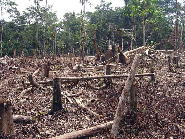
Deforestation has reduced the habitat critical to the survival of native species. An estimated 50 percent of the earth’s species live in tropical rain forests, which only cover about 5 percent of the earth’s surface. Tropical rain forests in the Amazon Basin are being cut down at an unsustainable rate, creating serious environmental problems. Loggers cut down the large trees, and the rest are usually burned to allow the ash to provide nutrients for other plants. The cleared areas are most often used by cattle ranchers until the soil is no longer viable. Then more forest is cut down and the process continues.
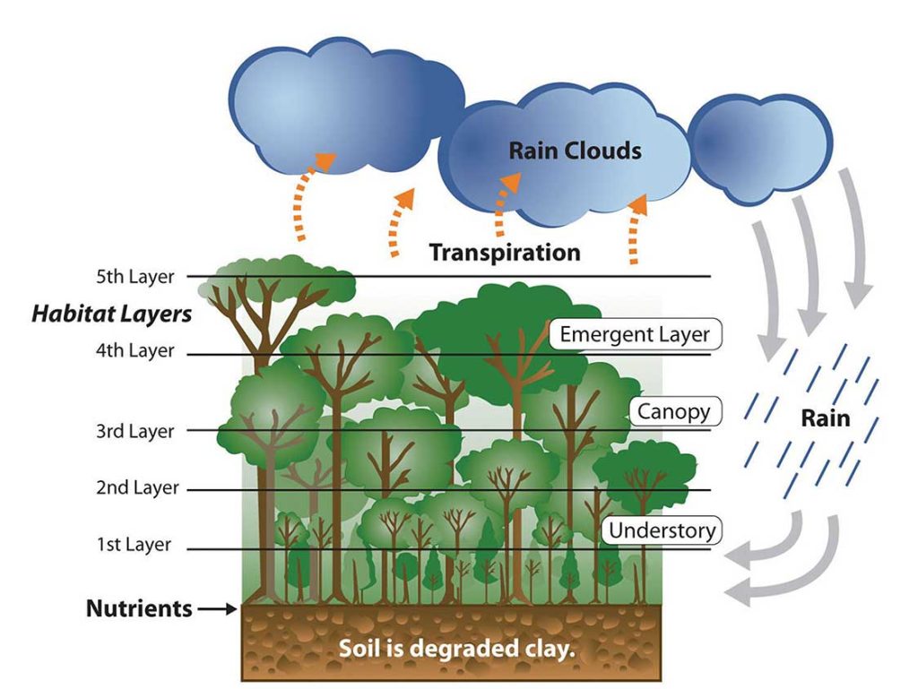
The forest has many layers of habitat. Soils in the tropics are extremely low in nutrients, which have been leached out by the abundant rainfall. Leaching is a process in which the nutrients dissolve in rain water, and then drop below the root zone of crops as the water percolates into the ground. Most of the nutrients are on the surface layer of the ground built up from falling leaves, branches, and debris decomposing on the forest floor. The removal of the forests removes these nutrients and also results in serious soil erosion.
Forest studies have indicated that tropical rain forests are actually quite resilient and can recover with proper forest management. However, clear-cutting large, wide areas for timber leaves an area devastated for an extended period. Clear-cutting could be replaced by strip cutting, which would harvest trees in narrower strips, leaving rows of trees standing. Strip cutting allows for more edges to be available for young plants to get their start to replenish the forest.
D. Regional Brazil
The core-peripheral spatial relationship can help us understand the power of Brazil’s southeast core and the natural resource base of the country’s peripheral north. This can explain the basic layout of Brazil’s economic geography, but the northeast, the west central, and the south are three additional regions to consider that contribute to the geographic understanding of the country. Each has specific qualities that make it unique in Brazil’s diversity of landscapes.
The northeast region is anchored along the coast, where plantation agriculture thrived during the colonial era. African slaves became the main labor base, and once freed, they made up most of the population. This agricultural region still grows sugarcane along the coast and other crops inland where the rainfall is reduced. The inland region includes parts of the Brazilian Highland, which runs parallel to the coast. Agriculture has traditionally required a large labor base, and family sizes in rural areas have been larger than their urban counterparts. This trend has given rise to a regional population of more than fifty million. However, the agriculture-based economy has not been able to supply the number of jobs and opportunities required for this large population. Poverty and unemployment in the northeast are high and have a devastating effect on the people. Some farms are not large enough for families to make a living on. Individuals in the northeast have developed a pattern of migration to the larger cities of the core area, looking for opportunities and employment—a pattern that fuels the self-constructed housing in the favelas of Rio de Janeiro and São Paulo.
The west central region has been opening up for development since the last part of the twentieth century and has experienced enormous advancements in industrial agriculture. In this region, vast cerrado grasslands are being plowed and converted into colossal fields of soybeans, grains, and cotton. The northwest portion of the cerrado is the huge Motto Grosso Plateau, which almost covers the largest state of the region. The landscape of this plateau is mainly scrub forest and savanna. Traditionally, the savanna portions have been used for grazing livestock, but in recent years more of the land is being plowed for growing agricultural crops. The entire west central region of Brazil is a giant breadbasket for the country. Its full agricultural potential has not been reached. Industrial agriculture requires infrastructure and transportation networks to transport the harvests to market, but the government has not kept up with the development of infrastructure at the same rate as the private sector has been developing industrial agricultural production. This region has enormous potential for agricultural expansion in the future.
Located on the eastern edge of the west central region is the forward capital of Brasilia. Its creation was prompted by the need to further develop the country’s interior. Built in 1960 and now a metropolitan center with more than 3.8 million people, the city was planned and designed to be a capital city. Because of its rapid growth and development, the city faces issues similar to those found in Rio de Janeiro or São Paulo. Rural-to-urban shift has brought many rural people to Brasilia in search of opportunities and employment. Just as Rio de Janeiro and São Paulo have favelas, Brasilia has slums and self-constructed districts, too. Moving the capital to Brasilia moved the focus from the coastal region of the south to the interior. However, a large percentage of the interior lies beyond the city of Brasilia. Highways that reach the Amazon can be accessed from the capital, but large areas of Brazil’s interior remain a frontier unexploited by development. Developing these areas may bring great opportunities and benefits to the country; however, recent development activities have also brought devastation to the tropical rain forests in many parts of the frontier.
The three states of the south region are located well south of the Tropic of Capricorn and extend south to the border with Uruguay. This extrusion is often called South Brazil. Brazil was colonized by the Portuguese, but many of the immigrants to the south were from other parts of Europe, including Germany and Italy. The Italian immigrants developed a growing wine industry, and the German immigrants raised cattle and grew other crops. The region’s good soils and moderate climate support many types of agriculture, which have dominated the early development of the region. Success in growing rice and tobacco and raising livestock has brought prosperity to the people who live here. Brazil has been one of the world’s main producers of tobacco for many years, and the tobacco from the south is highly regarded for its nicotine content.
The south is one of Brazil’s most affluent regions, and it has gained much wealth from agricultural activities. Farming is only one of the region’s highly developed economic activities. The area is also blessed with natural resources such as coal that is shipped north to the main cities where steel is produced. The wealth of the region has provided support for high-tech industries, which are attracted to the region because of the supply of skilled labor, access to quality transportation, and communication links. Computer companies have established software firms that have in turn attracted other new companies. A technology center similar to California’s Silicon Valley has combined with the manufacturing complex that has sprouted up along the coast of the south. The government and the business community have both provided economic incentives for these and other emerging enterprises.
Key Takeaways
- Brazil was a Portuguese colony during the colonial era. This is why the Portuguese language and the Catholic religion are dominant components of the Brazilian culture. The strong African heritage comes from the many African slaves brought in during the colonial era to work the plantations. Immigrants from many other countries have settled in Brazil as well.
- The urban southeast, with its large cities of São Paulo and Rio de Janeiro, represents the core
economic area of the country. The large cities of Brazil continue to expand to accommodate the influx of new immigrants. The outer edges of the cities expand through self-construction in slums called favelas. - The northern regions of the Amazon Basin represent the periphery of the country. The north is being exploited for its natural resources. Development patterns have caused extensive deforestation of the tropical rain forest of the region. The main causes are agriculture, logging, and mining.
- Other regions of Brazil include the west central, with extensive agricultural activities; the northeast, heavily populated with serious poverty; and the south in the protruded area bordering Uruguay, which is an affluent region with high standards of living.
8.4 The Southern Cone
Learning Objectives
- Summarize the main physical features and regions of the Southern Cone.
- Identify and locate the urban centers and understand the pattern of population distribution in
the three countries of the region. - Describe the ethnic consistency of each country. Explain the pattern of immigration that created
the region’s heritage. - Explain why Argentina has great potential for economic growth.
- Outline how Chile has emerged as a strong and stable country and discuss its human and
natural resources.
The Southern Cone region of South America includes the countries of Uruguay, Argentina, and Chile. The name is an indication of the physical shape of the southern portion of the continent. The region is located south of the tropics. The Tropic of Capricorn runs just north of Uruguay and cuts across the northern regions of Argentina and Chile. The Southern Cone has more moderate temperatures than the tropics. Type C climates dominate in Uruguay, the Pampas region of Argentina, and central Chile. The region has extremes in weather and climate. The Atacama Desert and Patagonia both have type B climates because of a lack of precipitation, which stems from the rain shadow effect of the Andes Mountains. Highland type H climates follow the Andes chain through the region and exhibit their typical pattern of warmer temperatures at lower elevations and colder temperatures at
higher elevations.
The countries of the Southern Cone share similar economic and ethnic patterns. Agriculture has been a major focus of the region’s early development pattern, but today a large percentage of the population is urbanized. The European heritage of most of the population ties this region to Europe as an early trading partner. The global economy has given cause for these countries to form trade relationships with many countries. The physical geography has provided many opportunities for human activities. The mountains, plains, and coastal areas provide a diversity of natural resources that have been exploited for national wealth. All three countries have primate cities that hold a high percent of the country’s population. Primate cities are usually twice as large as the next largest city and usually are exceptionally expressive of the national feeling and culture. In this case, all three primate cities are also the capital cities of each country. The Southern Cone is an urban region with higher incomes and higher standards of living than many other parts of South America.
A. Argentina
South America’s second-largest country is Argentina. In physical area, Argentina is ranked eighth in the world. The Andes Mountains span its entire western border with Chile. At the southern end of the continent is Tierra del Fuego. Argentina is a land of extremes. Mt. Aconcagua is the highest mountain in the Western Hemisphere at 22,841 feet in elevation, and Laguna del Carbon is the lowest point in the Western Hemisphere at −344 feet below sea level. Parts of the northern region have a tropical climate; the southern region extends into tundra-like conditions with treeless plains.
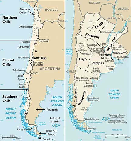
Physical Regions
Argentina can be categorized into a number of regions that correlate roughly with the varied physical and cultural landscapes of the country. The main regions include Chaco, Northern, Mesopotamia, Cuyo, Pampas, and Patagonia. The Northern region of Argentina has one of the highest average elevations because of the Andes Mountain Ranges. The Andes ranges widen as they proceed northward to the west of Chaco and are home to fertile river valleys. The northern ends of the ranges extend into Bolivia and enter the Altiplano of the Central Andes.
The Chaco region, which is formally called the Gran Chaco, extends from northern Argentina into western Paraguay. Scrublands and subtropical forests dominate the landscape. There is a wet season as well as a dry season suitable for raising livestock and some farming. Western Chaco, which is closer to the Andes, is drier with less vegetation and is known for its high temperatures during the summer months. To the east, the Chaco region receives more rainfall and has better soils for agriculture. The agrarian lifestyle dominates the cultural heritage of this region. In the 1920s and 1930s, the Chaco region attracted a large number of Mennonite immigrants from Canada and Russia who established successful farming operations mainly on the Paraguay side of the border and also extending into Argentina.
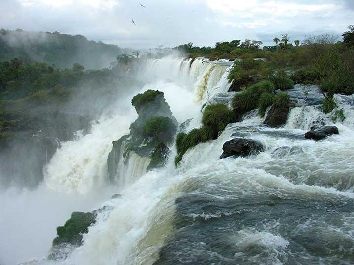
To the east of the northern region—on the other side of the Paraná River and reaching to the banks of the Uruguay River—is the region called Mesopotamia, whose name means “between rivers.” This unique region has a variety of features, from flatlands for grazing livestock to subtropical rain forests. The most noteworthy feature is the expansive Iguazú Falls on the Iguazú River, located on the border of Brazil and Argentina. It is a series of 275 parallel waterfalls that are just short of two miles across. It has the greatest average annual flow of any waterfall in the world. Most of the falls are more than 210 feet high; the tallest is 269 feet. The spectacular Iguazú Falls is a major tourist attraction, drawing people from all over the world.
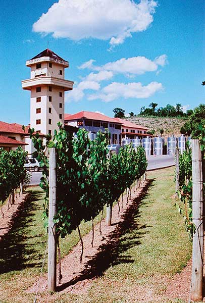
The Cuyo region is located along the Andes Mountains in the west central part of the country. Mt. Aconcagua is located here, along with other high mountain peaks. This arid region gets most of its moisture from melting snow off the mountains, which irrigate the rich agricultural lands that produce fruits and vegetables. The Cuyo is a major wine-producing region; it accounts for up to three-quarters of the country’s wine production. Picturesque vineyards and farms make the Cuyo a favorite tourist destination in Argentina. Mendoza is the country’s fourth-largest city. Low mountain ranges form the eastern border between the Cuyo and the Pampas.
The Pampas is a large agricultural region that extends beyond Argentina and includes a large portion of Uruguay and the southern tip of Brazil. With adequate precipitation and a mild type C climate, the Pampas is well suited for both agriculture and human habitation. The rich agricultural lands of the Pampas include the largest city and the country’s capital, Buenos Aires, which is home to up to a third of the nation’s population. The Pampas provides some of the most abundant agricultural production on the planet. The western grasslands host large haciendas (prestigious agricultural units) with cattle ranching and livestock production. This area has elevated Argentina to its status as a major exporter of beef around the world. Agricultural production has been a major part of the nation’s economy.
One hundred years ago, the export of food products made Argentina one of the wealthiest countries in the world. In today’s global economy, the profit margins in agricultural products are not as lucrative, and industrialized countries have turned to manufacturing for national wealth. Argentina continues to have a strong agricultural sector but has been increasing its industrial production in order to secure a strong economy.
Patagonia is a large expanse of the south that is semiarid because of the rain shadow effect. This area possesses enormous natural resources, including large amounts of oil and natural gas. Deposits of gold, silver, copper, and coal are found here. Raising livestock has been the main livelihood in Patagonia, which is otherwise sparsely populated. Patagonia includes the southern region of Tierra del Fuego and the rugged Southern Andes, which have some of the largest ice sheets outside Antarctica and many large glaciers that provide fresh water that feeds the region’s streams and rivers. Patagonia also has a number of scenic lakes. Abundant wildlife can be found along the Atlantic coast, including elephant seals, penguins, albatrosses, and a host of other species.
Population and Culture
Argentina, with a population of about forty million, is a country of immigrants and a product of the colonial transfer of European culture to the Western Hemisphere. During the colonial era, millions of people immigrated to Argentina from Western European countries such as France, Germany, Switzerland, Portugal, Greece, the British Isles, and Scandinavia. Additional immigrants came from Eastern Europe and Russia. Eighty-five percent of the population is of European descent; the largest ethnic groups are Spanish and Italian. The Mestizo population is only at about 8 percent. A small number of people from the Middle East or East Asia have immigrated and make up about 4 percent of the population. Less than 2 percent of Argentines declare themselves to be Amerindians.
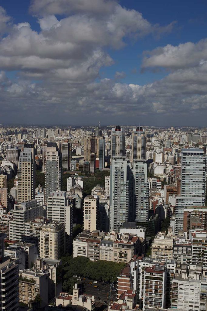
Old World European customs mix with New World Latin American traditions to form a cultural heritage unique to Argentina. This cultural heritage can be experienced in the metropolitan city of Buenos Aires, where all facets of society and culture can be found. With a population of about thirteen million—one-third of Argentina’s total population—Buenos Aires is a world-class city. Argentina is an urban country: more than 90 percent of the population lives in cities. The rural side of the culture has often been characterized as the traditional gaucho (cowboy) image of the self-reliant rancher who herds cattle and lives off the land. Beef is a mainstay of the cuisine in much of the country. The urban culture includes the traditional Argentine tango with music and camaraderie in upscale night clubs. These traditional images may be stereotypes, but the cultural scene in Argentina is heavily invested in the international trends of the modern world. The cultural landscape has become integrated with fashions and trends from across the globe.
B. Chile
Chile is a long, narrow country on the western edge of southern South America. Chile is 2,500 miles long and only 90 miles wide on average. This country borders the Pacific Ocean on one side and the Andes Mountains on the other. Chile has a variety of environmental zones, administrative districts, and climate patterns. Temperatures are cooler as one moves south toward Tierra del Fuego, which is split between Chile and Argentina. Rain has never fallen in select areas of northern Chile, which includes the Atacama Desert, one of the driest places on Earth and home to one of the world’s greatest copper and nitrate reserves. The sodium nitrates found in the Atacama Desert are used in plant fertilizers, pottery enamels, and solid rocket fuel.
The Rain Shadow Effect
The climate is due to the rain shadow effect. In northern Chile and the Atacama region, prevailing winds reach northern Chile from the east and hit the Andes Mountain chain, which are some of the highest mountains on the continent. The height of the Andes causes any moisture from rain clouds to precipitate on the eastern slopes. The western side of the Andes Mountains at that latitude receives little to no precipitation, causing extreme desert conditions in the Atacama region of Chile. Southern Chile receives a large amount of rainfall because the prevailing winds at that latitude come from the west. Here the winds, which have picked up moisture over the South Pacific Ocean, hit the western side of the Andes. The air then precipitates out its moisture as it rises up the mountainsides of the western slopes of the Andes. Less moisture reaches the eastern side of the mountains, creating a rain shadow with arid and dry conditions for the region called Patagonia in southern Argentina. The Andes are not as high in elevation in the south, which allows some precipitation to fall on the rain shadow side. Chile can be divided into three regions:
- Northern Chile, with the dry Atacama Desert
- Central Chile, with a mild type C climate, adequate rainfall, and good farmland
- Southern Chile, with lots of rainfall, rural, isolated islands, and mountains
Central Chile is the core region because it has a valuable port in Valparaiso and the country’s capital city, Santiago, which is also Chile’s most populous city. Central Chile is home to more than 90 percent of the country’s population.
Socioeconomic Conditions
The people of Chile are 95 percent European and Mestizo. They have worked to establish a good educational system and an increasing standard of living. The political system is faced with the unequal distribution of wealth that is common in Latin America and many other countries of the world. Half the country’s wealth is concentrated in the hands of about 10 percent of the population. About 50 percent of the population is on the lower end of socioeconomic scale. Dire poverty exists in Chile, but it is not as prevalent here as it is in the Central Andes, Paraguay, or Northeast Brazil. Chile has a thriving middle class that has made good use of the opportunities and education that Chile has offered them.
Chile is blessed with natural resources that include the minerals of the Atacama Desert, extensive fishing along the coast, timber products from the south, and agricultural products from central Chile. All these factors have brought about an emerging development boom and have attracted international trading partners. The stable government and growing economy have successfully kept inflation low and employment high, reduced poverty, and brought in foreign investment. In the globalized economy, Chile has managed to work with various trading partners to increase its advantages and opportunities in the international marketplace.
Chile has increased its trading activities with its counterparts in the Pacific Rim in Asia and North America. Chile has an abundance of fish in its coastal waters, copper and minerals in the Atacama Desert, and timber products in its southern region. The United States is one of Chile’s main trading partners. Chile’s main exports to the United States include paper, minerals, metals, and copper. Major agricultural products shipped to the United States include processed fruits, tomatoes, grapes, vegetables, and wines. One reason why the United States trades so much with Chile is due to the seasonal variations between the northern and southern hemisphere. When it is winter in the north, it is summer in the south. Each has an opposing growing season for fruits and vegetables that can complement the other.
Chile has strong ties to the economies of North America, but in spite of close ties with the north, Chile has retained its unique status in the Southern Cone. Chile still has its own currency even though countries with smaller economies, such as Ecuador and El Salvador, have adopted the US dollar as their medium of exchange. As of 2016, the NAFTA members of Canada, the United States, and Mexico, along with their trading partner of Chile, all used different currencies. The US dollar is the most widely used currency in the world and is also used in other Latin American countries. There has been talk of creating a similar currency within NAFTA called the Amero that would replicate the European Union’s solution, which was to create a single currency, the euro. World currencies fluctuate in value, and a stable currency would increase the capacity for creating larger trading blocs that could do business on a more even economic playing field. Chile has individual
free-trade agreements with all three members of NAFTA, so any change in currency with the NAFTA countries would also affect Chile.
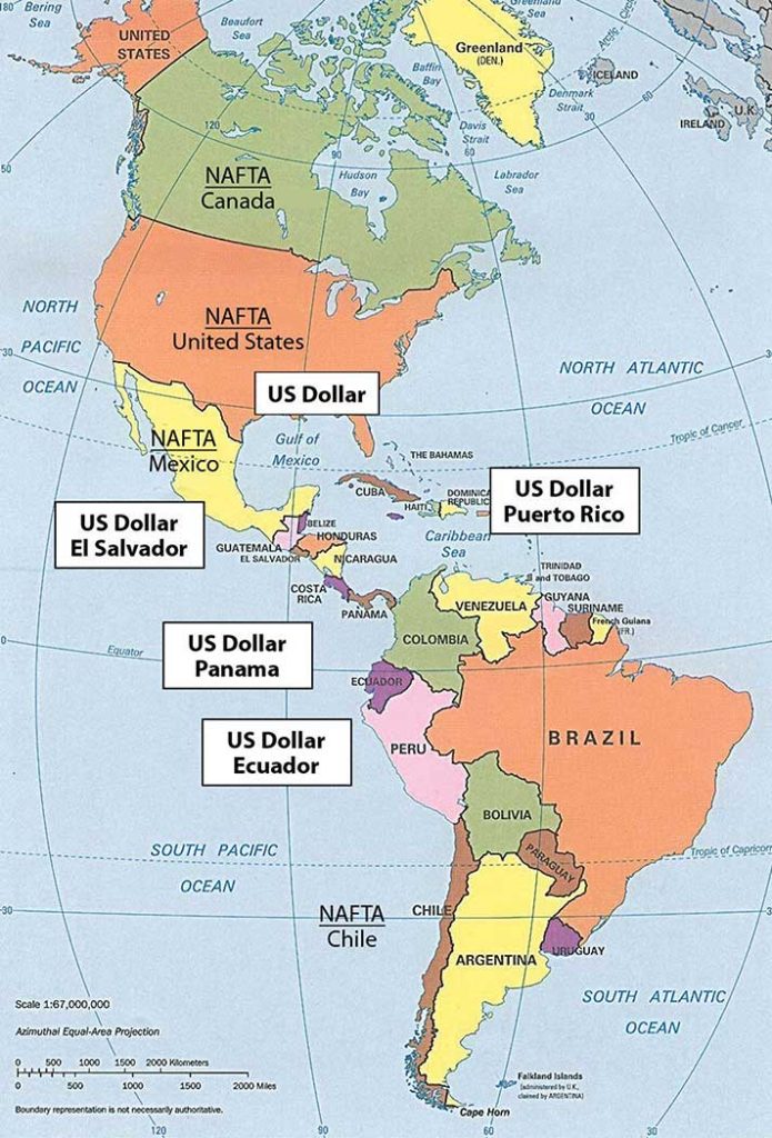
Key Takeaways
- The Southern Cone possesses large, diverse physical landscapes. Variations in terrain include tall Andean mountain peaks, desert conditions, prairie grasslands, and semitropical regions to the north.
- The Southern Cone is an urban realm with high percentages of the population living in large cities. Primate cities dominate each country. Large sections of each country’s interior make up the extensive rural periphery with activities based on natural resources.
- The Southern Cone is a European commercial area, and more than 85 percent of the population is of European ancestry. There are few Amerindian minorities or immigrants from Africa or Asia in the Southern Cone.
- Argentina is a large country in physical area and has a number of important regions that provide opportunities for economic prosperity. The country, however, has lacked a stable government and a consistent business climate to take advantage of Argentina’s favorable geographic situation.
- Chile has emerged on the global stage as a model for economic growth and stability. Its people have a higher standard of living, and the country has abundant natural resources. Chile has been a trading partner with NAFTA countries.
End-of-Chapter Summary
- The equator runs through the center of South America at its widest point and parallels the Amazon River. The two main physical features are the mighty Amazon River and the extensive Andes Mountains. The Andes, the longest mountain chain in the world, run from Venezuela to southern Chile. The Amazon River has the largest flow of water of any river on Earth, and the Amazon Basin is home to the world’s largest tropical rain forest. Rain forests cover less than 5 percent of the earth’s surface but have the richest biodiversity of any biome (environmental region), holding up to 50 percent of the world’s organisms.
- All of South America except for the Guianas was colonized by Spain and Portugal. The Guianas were located along the coast, where plantation agriculture was prominent. African slaves were the main labor base on the plantations. When slavery was abolished, slaves were replaced by indentured servants from the Asian colonies. Most of the population in Guyana and Suriname is from Asia. The cultural geography of South American can be understood by identifying the cultural regions formed by the majority ethnic groups the human activity in which they are engaged.
- Venezuela and Colombia dominate the countries of northern South America. Venezuela is an urban country, and much of its wealth is generated from the export of oil. Colombia is mountainous with vast tropical forests bordering the Amazon. Illegal drugs, oil, and coffee are Colombia’s three main export products. The United States is the main buyer of these products. The control of the physical territory of Colombia is divided between the government, drug cartels, and insurgent groups.
- South America’s Andean West region was the home to the ancient Inca Empire, which was conquered by Spanish conquistador Francisco Pizarro in 1533. Ecuador, Peru, and Bolivia have regions with high elevations in the Andes, including the Altiplano region with Lake Titicaca. Most of the population is Amerindian and holds to the customs and traditions of their heritage. Oil and mineral resources have been a main source of wealth for the region, but the profits have not always reached the majority population; instead, the wealth is often held by a minority at the top of the socioeconomic layer.
- Brazil was colonized by Portugal, which gave the country the Portuguese language and the Catholic faith. During the colonial era, a large number of African slaves were introduced to the country, which added to the country’s multicultural society. Many other Europeans and Japanese also immigrated to Brazil. The country’s large size allows for diverse human activities. The core urban area is located along the southeast coast, where the large cities of São Paulo and Rio de Janeiro are located. The forward capital of Brasilia is positioned inland on the edge of the core area.
- The rural periphery of Brazil includes the large Amazon Basin, with tropical rain forests and large undeveloped regions. Originally inhabited by Amerindian groups, the Amazon Basin is being developed for agriculture, mining, and the timber industry. This type of development is devastating large tracts of rain forest and placing increasing pressure on the few remaining indigenous groups. Large mining operations have fueled development, causing serious environmental concerns over habitat loss and the destruction of the tropical rain forest.
- The Southern Cone region of South America has a wide range of physical landscapes, from the semitropical areas of the north to the arid grasslands of the south in Patagonia. The Atacama Desert on the west coast is a product of the rain shadow effect from the high Andes. The rich agricultural lands of the Pampas are the breadbasket of the region, producing large amounts of grain and livestock. Coastal areas are good for fishing and allow access to foreign markets.
- The southern regions of South America also have heavily European populations. There are few Amerindians or people of African heritage. Most people live in urban areas, and one-third of Argentineans live in Buenos Aires. Chile has been a major trading partner with the North American Free Trade Agreement (NAFTA) nations and has a stable and growing economy. Argentina is a large country in physical area and has great potential for economic development.