10 North Africa and Southwest Asia
Introduction
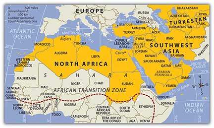
The realm of North Africa and Southwest Asia is large in physical area, but its regions share a number of common qualities. The physical area of this realm is divided into three regions: North Africa, Southwest Asia, and the countries of Turkestan (the geographic region of Central Asia). The countries in the North African region include the countries bordering the Mediterranean Sea and the Red Sea from Morocco to Sudan. The realm borders the Atlantic Ocean, the Sahara Desert, and the African Transition Zone. Egypt has territory in both Africa and Asia through its possession of the Sinai Peninsula. The second region, Southwest Asia, includes Turkey, Iran, the Middle East, and the Arabian Peninsula. The land on the eastern shores of the Mediterranean Sea is frequently referred to as the Levant and is often included as a part of the Middle East. Technically, the term Middle East only includes the five countries of Israel, Lebanon, Jordan, Syria, and Iraq, but in common practice Middle East refers to all of Southwest Asia. Central Asia, also referred to as Turkestan, includes the “stan” countries from Kazakhstan to Afghanistan in the region between China and the Caspian Sea. The suffix stan, meaning “land of,” is a common suffix for country names in Central Asia. Afghanistan is the only country of Central Asia that was not officially a part of the former Soviet Union.
10.1 Introducing the Realm
Learning Objectives
- Understand three basic traits the countries of the realm all share.
- Outline the two cultural hearths and explain why they developed where they did.
- Describe how the people of this realm gain access to fresh water.
- Understand how the events of the 2011 Arab Spring affected the realm.
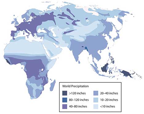
The countries of the realm share three key dominant traits that influence all other human activities. The first key common trait relates to the climate of the region. Though various climate types can be found in this realm, it is the dry or arid type B climates (desert and steppe) that dominate. Other climate types include the type H highland climate (cold temperatures at the high elevations with moderate temperatures at the bases) of the mountains of the Maghreb, Iran, or Central Asia and the more moderate type C climates (especially Mediterranean climate) in the coastal regions bordering the sea. The Mediterranean climate along the coastal areas attracts human development and is home to many large port cities. The overall fact is that vast areas of each region are uninhabited desert. North Africa has the largest desert in the world—the Sahara—which borders the Libyan Desert and the Nubian Desert. About one third of the Arabian Peninsula is part of the Empty Quarter of the Rub’ al Khali (Arabian Desert). Kazakhstan, Uzbekistan, and Turkmenistan have vast regions of desert with few if any inhabitants. This aspect of the realm reveals the importance of water as a valuable natural resource. Most people in the realm are more dependent on the availability of water than on the availability of oil.
The second trait is Islam: most of the people in the realm are Muslims. The practice of Islam in day-to-day life takes different forms in the various divisions of the religion. The differences between the divisions have contributed to conflict or open warfare. Islam acts as more than just a religion. It also serves as a strong cultural force that has historically unified or divided people. The divisive nature of the religion has often resulted in serious political confrontations within the realm between groups of different Islamic ideologies. Concurrently, the religion of Islam is also a unifying force that brings Muslims with similar beliefs together with common bonds. Islam provides structure and consistency in daily life. The faith can provide comfort and a way of living. The holy cities of Mecca and Medina are located in Saudi Arabia. Other holy cities for other divisions of Islam include Jerusalem and the two cities holy to Shia Muslims: Karbala and Najaf in Iraq. Islam dominates the realm, but other religions are significant in various regions. Israel is a Jewish state, and Christianity is common in places from Lebanon to Egypt. There are also followers of the Baha’i faith, Zoroastrianism, and groups such as the Druze, just to name a few.
The third factor that all three regions of the realm share is the availability of significant natural resources. North Africa, Southwest Asia, and Turkestan all have significant reserves of oil, natural gas, and important minerals. Not every country has the same reserves and some of the countries have very few or none at all. However, it is the export of oil that has dominated the economic activity as it relates to the global community. This realm is a peripheral realm. The resource that the realm can offer to the core economic regions of the world is the energy to fuel their economies and maintain their high standard of living. Enormous economic profits from the sale of these resources have traditionally been held in the hands of the elite ruling leader or his clan and do not always filter down to most of the population. The control of and profits from natural resources have become the primary objectives of the countries; this fuels conflicts and armed military interventions in areas such as Iraq and Afghanistan.
A. Cultural Hearths
Availability and control of fresh water have typically resulted in the ability of humans to grow food crops and expand their cultural activities. Hunter-gatherer groups did not settle down in one area but were more nomadic because of their seasonal search for food. As humans developed the ability to grow crops and provide enough food in one place, they no longer needed to move. The earliest human settlements sprang up in what is the present-day Middle East. Early human settlements provide some indication of early urbanization patterns based on the availability or surplus of food. The shift to permanent settlements included the domestication of livestock and the production of grain crops. Fruits and vegetables were grown and harvested. The activities of this era created humanity’s earliest version of the rural-to-urban shift. It is theorized that the ability to grow excess food provided the time and resources for urbanization and the establishment of organized communities, which often progressed into political entities or regional empires.
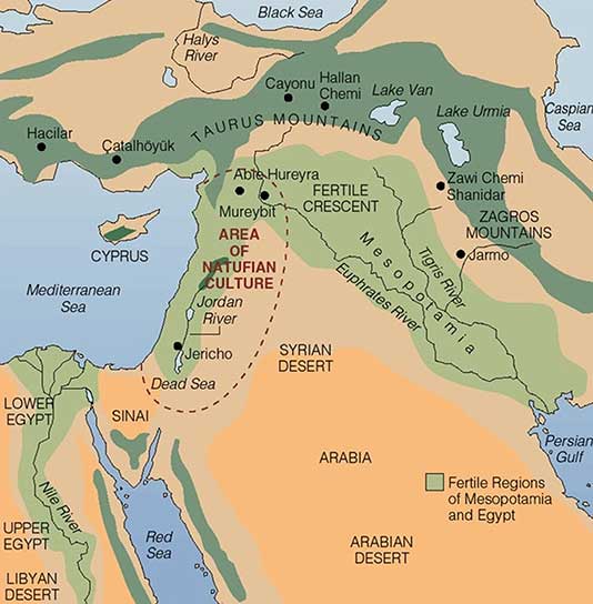
In the Middle East, two cultural hearths provide significant historical value to the concept of human development: Mesopotamia and the Nile Valley in Egypt. Both areas were settings for the growth of human civilization and are still being studied today. In Mesopotamia, a remarkable human civilization emerged along the banks of the Tigris and Euphrates Rivers in what is present-day Iraq, Syria, and southern Turkey. The climate, soils, and availability of fresh water provided the ingredients for the growth of a human civilization that is held in high esteem because of its significant contributions to our human history.
B. Mesopotamia and the Fertile Crescent
Mesopotamia, meaning “land between rivers,” is located between the Tigris and Euphrates Rivers. Neolithic pottery found there has been dated to before 7000 BCE. Humans in this area urbanized as early as 5000 BCE. People were settling in the Mesopotamia region, building magnificent cities, and developing their sense of human culture. Mesopotamia gave rise to a historical cradle of civilization that included the Assyrian, Babylonian, Sumerian, and Akkadian Empires, all established during the Bronze Age (about 3000 BCE or later). Famous cities such as Ur, Babylon, and Nineveh were located in the Mesopotamia region. The control of water and the ability to grow excess food contributed to their success. They developed extensive irrigation systems. Large grain storage units were necessary to provide the civic structure and to develop a military to protect and serve the city or empire. The human activity in this area extended around the region all the way to the Mediterranean Sea, which is where the term Fertile Crescent comes from.
Various ancient groups were well established on the eastern side of the Fertile Crescent along the Mediterranean coast. The cities of Tyre and Sidon were ports and access points for trade and commerce for groups like the Phoenicians who traded throughout the Mediterranean. Ancient cities such as Damascus and Jericho became established in the same region and were good examples of early human urbanization during the Bronze Age. These cities are two of the oldest continually inhabited cities in the world.
C. Nile River Civilization
Human civilization also emerged along the Nile River Valley of what is now Egypt. The pyramids and the Sphinx in the Giza Plateau just outside Cairo stand testimony to the human endeavors that took place here. Spring flooding of the Nile River brought nutrients and water to the land along the Nile Valley. The land could produce excess food, which subsequently led to the ability to support a structured, urbanized civilization. The Nile River is the lifeblood of the region. In the fifth century BCE, the ancient Greek historian Herodotus suggested that Egypt was “the gift of the Nile.” Egyptologists estimate the first dynasty ruled both Upper and Lower Egypt around 3100 BCE. Upper Egypt is in the south and Lower Egypt is in the north because the Nile River flows north. The terms “Upper” and “Lower” refer to elevation, or essentially “upriver” and “downriver.” The ability of humans to harness the potential of the environment set the stage for technological advancements that continue to this day. The Egyptian civilization flourished for thousands of years and spawned a legacy that influenced their neighbors in the region, who benefited from their advancements.
D. Access to Fresh Water
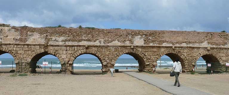
Water is one of the necessities for human existence, and human settlements have long been based on the availability of water for human consumption and agriculture, navigation, and the production of energy. In North Africa and Southwest Asia, the availability of water has an even greater relevance because of the arid climate. Methods used to address the shortage of water or to access fresh water have been nearly as diverse as the people who live here. Large populations of people can be found wherever there is fresh water. Water has historically been transferred from source to destination through canals, aqueducts, or special channels. Many ruins of extensive aqueducts from Roman times and earlier remain throughout the realm. The issues associated with water use continue to affect the lives of the people of this realm. Rapid population growth and industrialization have intensified the demand for fresh water.
Water can be found in the desert regions in a range of forms. For example, there are oases, springs, or noted wells from which people can draw underground water that is close to the surface. Mountainous regions such as the Atlas Mountains in North Africa or the Elburz Mountains in Iran trap moisture, which produces higher quantities of precipitation. The precipitation is then available in the valleys to irrigate crops. Discovering or developing other methods of acquiring fresh water is a requirement in areas without mountains.
E. Nile Water in Egypt
Egypt draws water from the Nile to irrigate fields for extensive food production. For thousands of years, floods of the Nile annually covered the land with fresh silt and water. This made the land productive, but the flooding often caused serious damage to human infrastructure. The building of the Aswan High Dam in the 1970s helped control the flooding of the Nile Valley. The river no longer flooded annually, and water had to be pumped onto the land. Over time, the constant and extensive use of this type of irrigation causes the small quantities of salt in the water to build up in the soil to serious levels, thereby reducing the land’s productivity. This process, called salinization, is a common problem in arid climates. To rid the soil of the salts, fresh water is needed to flood the fields, dissolving the salt and then moving the salty water back off the fields. High salinization in the soil and the reduction in agricultural productivity is a growing concern for Egypt. Egypt’s growing population places a high demand on the availability of food. More than half of the eighty million people in Egypt live in rural areas, and many of them make their living in agriculture, growing food that plays a critical role in the country’s economic stability.
F. Water from the Tigris and Euphrates
The major source of water in the Fertile Crescent region comes from the Tigris and Euphrates Rivers. Both have their origins in Turkey and converge to form the Shatt al-Arab (literally, “River of the Arabs”) waterway that flows into the Persian Gulf (which is called the Arabian Gulf by Arabs). The Euphrates is the longest river in Southwest Asia and flows through Syria from Turkey before entering Iraq. Turkey has developed large dams on both the Tigris and Euphrates for agricultural purposes and to generate hydroelectric power. As water is diverted for agriculture in Turkey there is less water flowing downstream for Syria or Iraq. Disputes over water resources continue to be a major concern in the Tigris-Euphrates Basin. The Atatürk Dam in Turkey is largest dam on the Euphrates, and it has a reservoir behind the dam that is large enough to hold the total annual discharge of the river. All three countries have dams on the Euphrates and both Turkey and Iraq have dams on the Tigris. The three countries signed a memorandum of understanding in 2009 to strengthen cooperation within the Tigris-Euphrates Basin. All three countries need the water for agriculture to produce food for a growing population. Agreements to share water have been difficult as a result of the Iraq War and the recent violence in Syria that have contributed to further political tension between the three countries.
G. Water Conservation in Israel
Israel has taken innovative steps to conserve water and use it efficiently. Drip irrigation mixed with fertilizers is called fertigation. Fertigation is used extensively in the area. Israel grows plantation crops such as bananas, which require large quantities of water. Banana groves are covered with material that allows sunlight to penetrate but reduces the amount of transpiration, which conserves water. Israel has worked to recycle water whenever possible. Gray water is water extracted from sewage that has been treated to be used in agriculture. Underground wells in the West Bank region provide water for a high percentage of people in both the Palestinian areas and Israel. The issue of control over the water is contentious at times. Just as the control of water may have been an important factor in the early Mesopotamian civilizations, it remains a point of political conflict in places such as Israel and the West Bank. The lack of fresh water and the heavier demand placed on water resources have caused countries that can afford it to desalinize seawater. Desalinization is used extensively in the oil-rich states of the Arabian Peninsula. Israel is implementing a similar plan to accommodate their increasing population and fresh water requirements.
H. Diversion of Water in Turkestan
Fresh water is in short supply in many of the desert regions of Turkestan in Central Asia. Agricultural production has traditionally been dependent on water flowing in rivers and streams that originated with the precipitation from the mountains, but as humans have developed canals and irrigation systems, water from rivers has been diverted for agricultural use. Vast fields of cash crops such as cotton were developed during the Soviet era for economic reasons, and the result had devastating consequences for the Aral Sea, which depended on the water from these rivers for its survival and has now shrunk to a fraction of its former size. More than half the population of Central Asia depends on agriculture for their livelihood. The other half, of course, requires water and food for their existence.
I. Arab Spring of 2011
The year 2011 brought about important changes for the human geography of parts of this realm. The year ushered in a wave of human activity that awakened the power of the citizens to speak out against conditions in their country and actively protest against their governments. North Africa, the Middle East, and the Arabian Peninsula experienced the highest levels of protests and insurgency. Political leaders that had been in power for extended periods were challenged and removed from office. Democratic reforms were requested or demanded by citizens seeking more individual freedom and greater access to political power. Uprisings in some of the countries were internal; other countries received external support or intervention. Overall, demonstrations, protests, and outright revolution involved millions of people desiring improved living conditions and a better future for themselves and their families.
Protests emerged in North Africa in the beginning of 2011. Tunisia was the first country in which leadership felt the heat of civil resistance and open revolution. In January, the Tunisian president of more than twenty-three years was forced to flee to Saudi Arabia. In Egypt, millions of protesters demonstrated in the streets against political corruption and the lack of reforms. The revolution of Egypt’s citizens was not an armed conflict, but it was an effective protest, because it eventually brought about the ouster of President Hosni Mubarak, who had been in office for almost thirty years. Demonstrations and protests continued against governments in Morocco and Algeria; the people voiced their concerns regarding issues such as high unemployment, poor living conditions, and government corruption. Libya’s protests erupted into a full-scale armed revolution as antigovernment rebels took control of the city of Benghazi in an attempt to topple Muammar Gadhafi’s forty-two years of authoritarian control of the government, oil revenues, and the people. The armed Libyan revolution was eventually successful in taking control of Tripoli and in removing Muammar Gadhafi and his family from power. The revolution in Libya was aided by North Atlantic Treaty Organization (NATO) air strikes and the implementation of a no-fly zone over the country.
The Middle East did not escape the Arab Spring of 2011. Protests in Jordan forced King Abdullah II to reorganize his government. The country experiencing the greatest impact was Syria. Major mass demonstrations and serious protests against the government were staged in a number of cities across the country. In Syria, the long-term leadership of an Alawite minority continues to run the government and control the military. The al-Assad family—a father and then his son—has ruled Syria since 1971. The Syrian government cracked down on the revolution with hardline measures aimed at subduing the protests and demonstrations. By September 2011, more than two thousand protesters had been killed in Syria, and many more were detained or tortured. Countless others fled to neighboring countries for their safety. The protesters in Syria wanted democratic reforms as well as the end of the al-Assad family reign.
The wave of change that swept over the realm in the Arab Spring of 2011 is an example of how centripetal and centrifugal cultural forces act on a state or region. The political landscape was altered or drastically changed in many countries. The impact of these changes will be realized in the years and decades to come.
Key Takeaways
- The realm of North Africa and Southwest Asia extends from the Atlantic Ocean along the Moroccan coast to the western border of China. It includes the regions of North Africa, Southwest Asia, and Central Asia (often referred to as Turkestan).
- Three basic features that dominate this realm include the arid type B climates, Islam as the predominant religion, and the export of petroleum and minerals to gain wealth. There are exceptions to all three features, but these three are found within most countries of the realm.
- The two main cultural hearths in this realm are located along the rivers in Mesopotamia and in Egypt. Control of and access to water resources to grow excess food were the basis for the success of the empires that flourished in these two areas.
- Fresh water is a valuable resource that is not always available in North Africa and Southwest Asia because of the climate and physical geography. Each region within the realm has developed its own methods to draw from or extract the valuable resource of fresh water.
- The Arab Spring of 2011 was a massive wave of protests and demonstrations by citizens of the realm against their governments over such issues as poor living conditions, high unemployment, government corruption, and the lack of democratic reforms. Various leaders were removed from office and governments were pressed to reform their power structures to allow for more shared governance and reduced political corruption.
10.2 Muhammad and Islam
Learning Objectives
- Summarize the early life of Muhammad and the origins of Islam.
- Analyze the differences and similarities among the three main monotheistic religions.
- Explain the process of spatial diffusion and the various forms it may represent.
- Outline the main divisions of Islam and the approximate percentages of the followers of
each division. - Explain how Islamic fundamentalism influences the debate between a religious state and a secular state
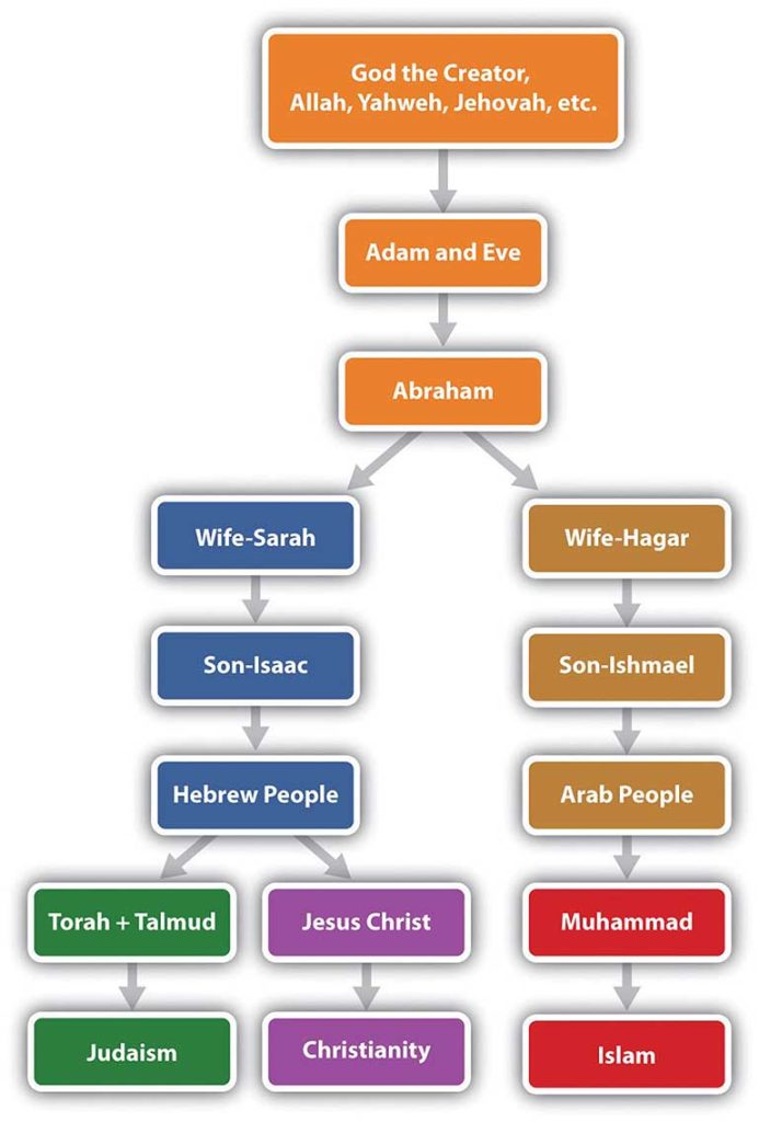
Located in the mountains of western Saudi Arabia, the city of Mecca (also spelled Makkah) began as an early trade center for the region and a hub for camel caravans trading throughout Southwest Asia and North Africa. Mecca is about forty-five miles from the Red Sea coast at an elevation of 531 feet. South of Mecca, the mountains reach more than 7,200 feet in elevation. According to Islamic tradition, the patriarch Abraham came to Mecca with his Egyptian wife Hagar and their son Ishmael more than two thousand years before the birth of the Prophet Muhammad (born 571 CE). When Hagar died, Abraham and Ishmael built the Kaaba (or Ka‘ba), a rectangular shrine that included a special stone, in Mecca. The shrine was destined to become one of the holiest sites for nomadic groups in Arabia. Abraham later died in Palestine in what is now the country of Israel. Centuries after Abraham’s death, the Kaaba and the rituals associated with it deteriorated and mixed with other local traditions.
A. The Prophet Muhammad
The traditional groups in the region of Arabia were polytheistic and worshiped their own gods. By the time of Muhammad, Mecca is said to have been a center of worship to more than 360 deities or gods; the greatest of these was Allah (meaning “the god”). Allah was known as the chief of the Meccan pantheon of gods and was worshiped from southern Syria to Arabia. Mecca was full of idols, temples, and worship sites. Tradition states that the god Allah was the only god without an idol; he would become the sole entity of Muhammad’s new Islamic religion.
Muhammad, born in Mecca 571 years after the birth of Christ and about 100 years after the fall of the Roman Empire, was orphaned at an early age, and was employed in a camel caravan when he reached his teens. His travels introduced him to many people, places, and issues.
Islamic tradition states that the angel Gabriel appeared to Muhammad while he was meditating in a mountain cave in 610 CE, when he was about forty. Muhammad was given words from Allah, which he recited from memory to his followers. According to tradition, Muhammad was illiterate; his supporters wrote down his words, compiling them into the Koran (Qur’an), the holiest book of Islam. Muhammad was the founder of the new religion, which he called Islam (meaning “submission to Allah”). The term Muslim
(meaning “one who submits”) refers to a follower of Islam.
After Muhammad returned to Mecca and related his visions and Allah’s words from the angel Gabriel, he began to speak out against the city’s vices and many gods. He stated that there was only one god: Allah, the same creator god of Abraham. His message was not well received: in 622 CE the people of Mecca forced Muhammad out. He fled to the safety of the nearby city of Yathrib in a journey known as the Hegira. Muhammad later renamed the city Medina (“city of the prophet”).
Launching out from Medina, Muhammad and those loyal to him defeated the army of Mecca and converted the city into Islam’s holiest place. They destroyed all Mecca’s idols and temples except the Kaaba. Muhammad’s teaching united the many Arabian groups under one religion. Since the Koran was written in Arabic, Arabic became the official language of Islam. The Kaaba and the mosque built at Mecca became the center of the Islamic world and a destination for Muslim pilgrims. Islam brought a new identity, a faith in one god, and a set of values to the Arab world. Islam made sense in a world with many traditional beliefs and few unifying principles.
It is important to keep in mind that monotheism was not new: Christianity had been around for more than six hundred years. Judaism and Zoroastrianism in Persia had been around for centuries before Christianity. The principles of Islam and Muhammad’s teachings are a continuation of Judaism and Christianity. All three traditions assert a faith in a divine creator, with important messages coming through prophets or holy messengers. All three religions acknowledge Abraham as a founding patriarch. Muslims believe that Moses and Jesus were prophets and that Muhammad was the greatest and final prophet. All three religions have stories about creation, Adam and Eve, the flood, and other stories that have been adapted to the traditions and characters of each religion.
Religion is a part of culture. The religions that emerged out of the Middle East absorbed many of the existing cultural traits, traditions, or habits of the people into their religious practices. Early Islam adapted many Arab cultural traits, styles of dress, foods, and the pilgrimage and folded them into its principles. Early Christianity and Judaism also adopted cultural traits, holidays, styles of dress, and cultural traditions.
B. Spatial Diffusion
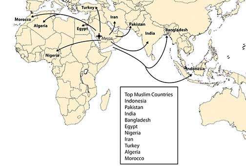
The spread of Islam was accomplished through trade and conquest. Mecca was a center of trade. When camel caravans left Mecca, they carried Muhammad’s teachings with them. Islam diffused from Mecca and spread throughout the Middle East and into Central Asia and North Africa. The geographic principle of spatial diffusion can be applied to any phenomenon, idea, disease, or concept that spreads through a population across space and through time. The spatial diffusion of Islam outward from Mecca was significant and predictable.
There are two main types of spatial diffusion: expansion diffusion and relocation diffusion. Expansion diffusion has two main subtypes: contagious diffusion and hierarchical diffusion. A religion can spread from individual to individual through contagious diffusion when a religion starts at one point and propagates or expands outward from person to person or place to place in a pattern similar to the spreading of a disease. Another way a religion can spread through expansion diffusion is hierarchically, when rulers of a region convert to the religion and decree it as the official religion of their realm; the religion filters down the political chain of command and eventually reaches the masses. The second type of diffusion, relocation diffusion, takes place when the religion is carried by people to a new place as they migrate there, thus relocating the religion. When Islam jumped from the Middle East to Indonesia, it diffused through relocation. Relocation diffusion also occurred when Muslims migrated to the United States. As of 2010, Islam had attracted as many as 1.5 billion followers, second only to Christianity, which has about 2 billion followers.
C. The Five Pillars of Islam
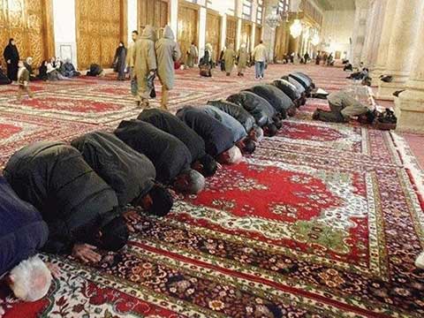
The basic tenets of the Five Pillars of Islam create the foundational structure of Islam. Prayer is an important part of the religion. A Muslim must offer prayers five times a day: before sunrise, at midday, at midafternoon, after sunset, and in the early evening. During prayer, Muslims face toward the compass direction of Mecca. Before clocks and time were well established, a mosque leader would climb a minaret (a tall tower next to the mosque, their place of public worship) and call the faithful to prayer at the required times of day. Muslims gather together for common prayer on Friday, which is a time to unite the community of believers. Mosques sprang up after Muhammad died, and they became the center of community activities in the Islamic world.
The Five Pillars of Islam can be translated as follows:
- Express the basic creed (Shahadah). Profess that there is no god but Allah and his messenger and prophet is Muhammad.
- Perform the prayers (Salat). Pray five times a day, facing Mecca.
- Pay alms or give to charity (Zakat). Share what you have with people who are less fortunate.
- Fast (Sawm). During the month of Ramadan, abstain from personal needs, drinking, and eating from dawn to dusk (as one’s health permits).
- Make the pilgrimage to Mecca (Hajj). Conduct at least one pilgrimage to the holy city of Mecca (if within one’s capacity).
D. The Death of Muhammad
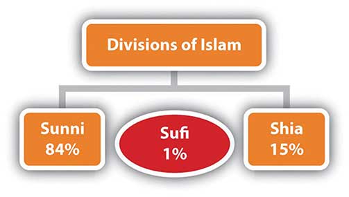
Muhammad died in 632 CE at the age of sixty-two. He never claimed to be a god or anything other than a mere mortal. His tomb is located in Medina, the City of the Prophet. No provision was made to continue Muhammad’s work after he died. One division thought his successor should be a blood relative. This division led to the Shia (or Shi’ite) branch of Islam, which makes up about 15 percent of Muslims. Others felt that the successor should be a worthy follower and did not need to be a blood relative. This branch became known as Sunni, which makes up about 84 percent of Muslims. Various smaller branches of Islam also exist, including Sufi, which approaches the Islamic faith from a more mystical and spiritual perspective.
In understanding the Middle East, it is critical to understand the Sunni and Shia divisions of Islam. The Shia and Sunni divisions of Islam have sometimes had divergent beliefs, resulting in conflicts. In the early sixteenth century, the Persian Empire, which is now Iran, declared the Shia branch its official religion. Its surrounding neighbors were predominantly Sunni. This divergence is part of the basis for the current civil unrest in Iraq. The two divisions of Islam currently vie for political power and control in Iraq. The majority of the Arab population in Iraq, about 60 percent in 2010, follows the Shia division of Islam, but the leadership under Saddam Hussein until 2003 was Sunni. The Shia majority in Iraq who are Arab share their faith with the Shia majority in Iran who are ethnically Persian.
E. Secular State versus Religious State
Islam has a code of law called the Sharia criminal code, which is similar to Old Testament law. The Sharia dictates capital punishment for certain crimes. For example, if a person is caught stealing, his or her arm would be severed. For more serious offenses, he or she would be beheaded or stoned to death. Some countries use the Sharia as the law of their country. Countries are called religious states (Islamic states in this case) when religious codes take precedence over civil law. States in which people democratically vote on civil law based on common agreement are called secular states. Whereas secular states attempt to separate religious issues and civil law, religious states attempt to combine the two. Iran is a good example of an Islamic religious state, and Turkey is a good example of a secular state. When the United States invaded Iraq in 2003 and Saddam Hussein was removed from leadership, the country entered a transitional period in which they had to decide if the country would develop into an Islamic state with the Sharia or move to a democratically elected government with civil law. The debate on these issues continually surfaces in many of the countries in North Africa and Southwest Asia whenever transition occurs.
The cultural forces of democratic reforms and Islamic fundamentalism have been pushing and pulling on the Islamic world. Democratic reformers push for a more open society with equality for women, social freedoms for the people, and democratically elected leaders in government. Islamic fundamentalists pull back toward a stricter following of Islamic teachings; they oppose what they consider the decadent and vulgar ways of Western society and wish to restrict the influence of liberal, nonreligious teaching. A rift between militant Islamic fundamentalists and moderate Islamic reformers is evident throughout the Muslim world. Militant leaders strive to uphold the Sharia criminal code as law. Moderate reformers work toward a civil law based on democratic consensus. This rift adds to the conflicts that have been occurring in this realm. Islamic fundamentalists push for a more traditional and conservative society and express opposition to the United States’ intervention in the realm. The Muslim world will continue to confront such arguments over the future direction of Islam in a globalized economy.
Key Takeaways
- Islam has its origins with Muhammad, who was born 571 years after the birth of Jesus, when Christianity was well established. Muhammad received his revelations through the angel Gabriel and passed them to his followers, who wrote down his words into what became the Koran.
- Islam is the youngest of the three major monotheistic religions of the realm: Judaism, Christianity, and Islam. All three trace their origins back to the patriarch Abraham. Other monotheistic religions, such as the Baha’i faith and Zoroastrianism, are also evident in the Southwest Asia.
- Spatial diffusion can be applied to any phenomenon, idea, disease, or concept that spreads through a population across space and through time. Islam has diffused through both expansion diffusion and relocation diffusion to become the second most followed religion in the world.
- Since the death of Muhammad, Islam has divided into a number of different factions. The two most prevalent divisions of Islam are Sunni (followed by about 84 percent of Muslims) and Shia (followed by about 15 percent of Muslims). Other minor divisions of Islam, such as Sufi, also exist.
- Religious states are structured around laws based on religious regulations that are usually determined by religious leaders. Secular states are structured around civil law, which is decided on by democratic consensus.
10.3 North Africa and the African Transition Zone
Learning Objectives
- Summarize the historical geography of North Africa, identify the major physical features and the main cities, and understand who the people are and where most of the population lives in the region.
- Understand the unique geographic qualities of the Maghreb and explain how this region is
connected to Europe. - Outline the political issues in North Africa and understand the transitions and conflicts occurring in the governments of the region.
- Describe the main qualities of the African Transition Zone and explain how the dynamics of this zone are affecting the country of Sudan.
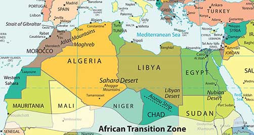
North Africa’s primary connection with the Middle East and Central Asia is that Islam diffused to North Africa from the Middle East and Central Asia. Today, it is a Muslim-dominated realm with Arabic as its primary language. Historically, the ethnicity of North Africa was predominantly Berber with the nomadic Tuareg and other local groups interspersed. When Islam diffused into North Africa, the Arab influence and culture were infused with it. Modern Egypt has become the cornerstone of the Arab world; more Arabs live in Cairo than in any other city on Earth. The three main areas of interest are the Maghreb of the northwest; the Nile River valley in the east; and the African Transition Zone, where the Sahara Desert transitions into the tropical type A climates of Central Africa’s equatorial region.
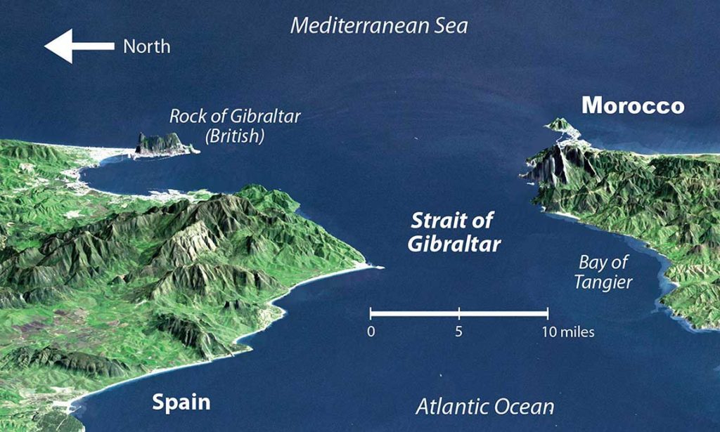
Islam diffused through North Africa to the Berber people of the Maghreb and entered Europe across the Strait of Gibraltar to the Iberian Peninsula. The Arab-Berber alliance, called the Moors, invaded Spain in 711 CE. The Islamic influence thrived in Iberia and would have continued into mainland Europe if not stopped by Christian forces such as Charles Martel’s army in the famous Battle of Tours. Islam was eventually pushed out of the Iberian Peninsula and held south of the Strait of Gibraltar. Islamic architecture and influence remain part of the heritage of Iberia.
The historical geography of North Africa is not complete without an understanding of the European influences that have dominated or controlled this region for centuries. The Roman Empire controlled much of the coastal area of the Mediterranean during its zenith. The Romans built ports, aqueducts, roads, and valuable infrastructure. After the fall of the Roman Empire, common bonds of religion and language were created for the people through the invasion of the Arabs, who introduced the Islamic faith. North Africa was later dominated by European colonialism. France controlled and colonized the region of the Barbary Coast along North Africa’s western waterfront, including Algeria, Tunisia, and parts of Morocco. Italians colonized the region that is now Libya. The Barbary Coast of the Mediterranean was once a haven for pirates and a danger to shipping during the colonial era. Even the United States involved itself with wars against the pirates off the coast of the Berber states of North Africa during the early 1800s. After the fall of the Ottoman Empire at the end of World War I, Britain controlled Egypt and parts of the Sudan. The Spanish colonized parts of Morocco and Western Sahara. In due time, resistance movements were successful in defeating the colonial powers and declaring independence for all the countries of North Africa. However, the European influence remains through the region’s dependence on trade and economic partnerships with Europe.
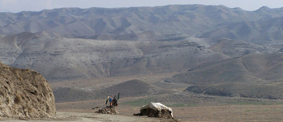
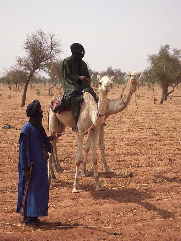
North Africa is separated from Sub-Saharan Africa by the African Transition Zone, a transitional area between Islamic-dominated North Africa and animist- and Christian-dominated Sub-Saharan Africa. It is also a transition between the Sahara Desert and the tropical type A climates of Africa’s equatorial region. This is a zone subject to shifting boundaries. The region was once a major trade route between the Mali Empire of the west and the trade centers of Ethiopia in the east. Camel caravans have crossed this sector of Africa for centuries, and camel caravans from Mecca might have traveled across this zone. Many nomadic groups continue to herd their livestock across the region in search of grazing.
A. The Maghreb: “Isle of the West”
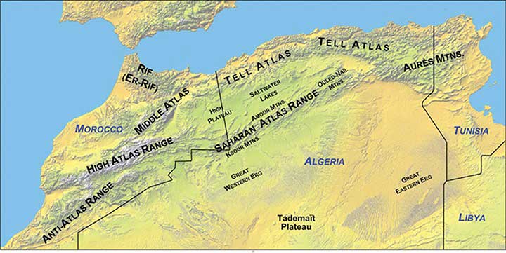
The Maghreb is a region extending from Morocco to Libya that is distinguished by the main ranges of the Atlas Mountains, which reach elevations of nearly thirteen thousand feet. The main Atlas range is often snow-covered at higher elevations. The Maghreb, which in Arabic means “Isle of the West,” receives between ten and thirty inches of rainfall per year. This is substantially more rainfall than what is received in the Sahara Desert to the south. The Atlas Mountains extract precipitation from the air in the form of rain or snow, which allows fruits and vegetables to be grown in the fertile mountain valleys of the Maghreb. To the south of this region is the vast Sahara Desert with lower precipitation and warmer temperatures. Libya is actually outside the range of the Atlas Mountains but is associated with the Maghreb by most local inhabitants.
Aided by a moderate type C Mediterranean climate, the northern coastal region of the Maghreb and the mountain valleys are a center for agricultural production, including grapes, dates, oranges, olives, and other food products. Think about how geography affects population: Which climate type do most human groups gravitate toward? What conditions will you find when you combine this climate type and generous quantities of water and food? As you fit the pieces of the geographic puzzle together, you can understand why populations centralize in some places and not in others. The Maghreb is an attractive place for human habitation, but it borders on the inhospitable vastness of the Sahara Desert. Most of the Maghreb’s residents live in cities along the Mediterranean coast. There are few people in the vast desert interior of these countries. The exceptions are groups such as the nomadic Tuareg that are found in the Sahara.
All the countries of the Maghreb have former connections to Europe. These ties have strengthened in recent years because of an increase in trade and the economic dependencies that have been created between Europe and the Mediterranean. North Africa can grow fruit and vegetable crops that are not as plentiful in the colder northern latitudes. In the last half of the twentieth century, an enormous amount of oil was discovered in the Maghreb, and Europe has a growing need for energy. The discovery of oil changed the trade equation: oil and natural gas revenues subsequently advanced past agricultural goods as the main export products. Oil and natural gas exports now make up 95 percent of the export income for Algeria and Libya.
Economic Geography of the Maghreb
Europe has small families with fewer young people to fill entry-level service jobs, and North Africa has a burgeoning population of young people seeking employment. Many people from North Africa speak the languages of their former colonial masters, and when they leave North Africa seeking employment, they find the transition to a European lifestyle relatively straightforward. Migration from the shores of North Africa to Europe is not difficult; the Strait of Gibraltar, for example, is only about nine miles across from
Morocco to Spain.
European countries have attempted to implement measures to halt the tide of illegal immigration into their continent from North Africa but have not been successful. The need for cheap labor in European countries is a major economic factor in this equation. The core-periphery spatial relationship creates the push-pull forces of migration based on opportunities and advantages. Europe needs cheap labor and more energy, provides employment opportunities, and has an advantage in its higher standards of living: these forces attract immigration and pull people toward Europe. North Africa can supply labor and oil, has high levels of unemployment, and suffers from poor economic conditions: these factors push people to emigrate from North Africa to places where conditions are more attractive. Europe is the core economic region, and North Africa is the peripheral economic region. People usually shift from periphery to core in their migration patterns, and this is the case across the Mediterranean.
B. The Nile River and Egypt
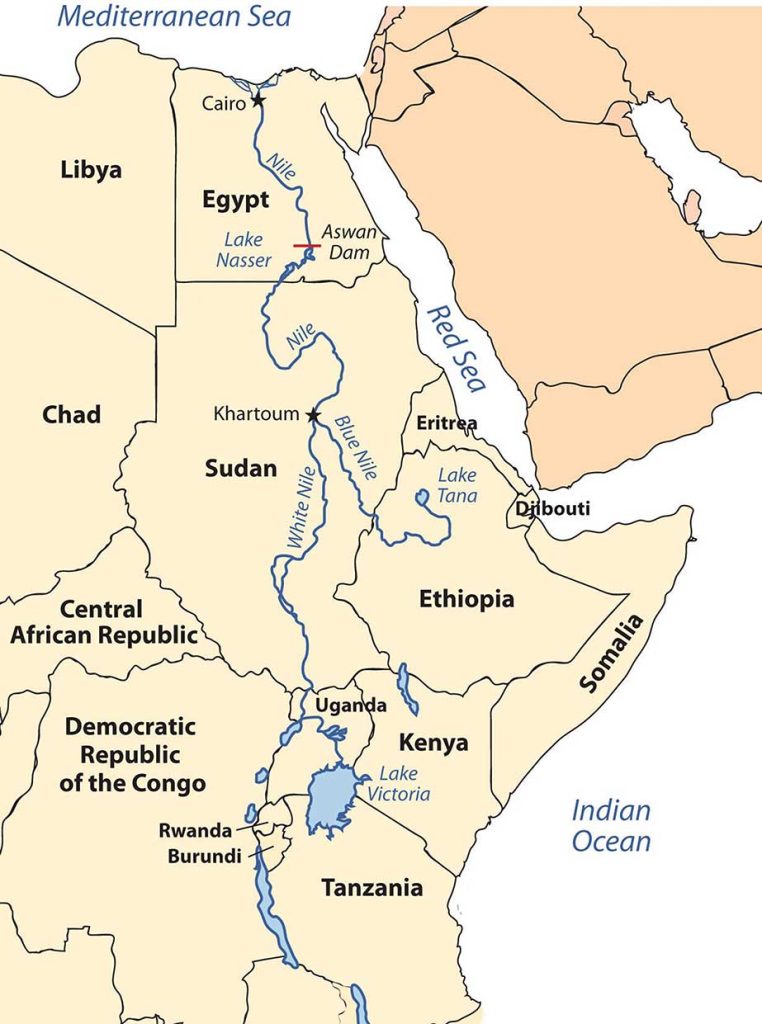
The Nile River originates in East Africa in Lake Victoria and in Ethiopia in Lake Tana. The White Nile flows north from Lake Victoria through Uganda and into Sudan, where it converges with the Blue Nile at the city of Khartoum, Sudan’s capital. The Blue Nile originates in Lake Tana in Ethiopia. From Khartoum, the Nile River flows north through the Nubian Desert into Egypt, where it eventually reaches the Mediterranean Sea. The fresh water of the Nile is a lifeline that enables agriculture and transportation and supports a growing human population in the region.
Until the Aswan High Dam was completed in 1968, the river flooded its banks yearly, depositing silt and nutrients onto the soil and causing enormous damage to infrastructure. As far back as when the pharaohs ruled Egypt, the people used flood irrigation to grow their crops. Today, water is pumped from the controlled Nile River onto the fields to water crops. This change has increased the number of crops that can be grown per year. However, it has also caused a buildup of salt in the soil, resulting in declining soil quality. Without annual flooding, the salts cannot be dissolved away but remain in the soil, reducing yields. Almost a third of Egypt’s population works in agriculture; about half the population is rural.
Population Dynamics
Cairo, Egypt’s capital, lies at the northern end of the Nile River. With a population of more than ten million, it is the largest North African city and home to more Arabs than any other city in the world. It is considered the cornerstone city of Arab culture. Cairo is so crowded that more than a million people live in its old cemetery, the City of the Dead. Cairo’s residents, and the millions of people in Egypt, depend on the Nile River for their survival. About 95 percent of Egypt’s population lives within fifteen miles of the Nile River. As the population has grown, urban expansion has encroached on the farmland of the Nile Valley. Egypt can no longer produce enough food for its people; about 15 percent of its food comes from other countries, mainly the United States.
Conflicts between democratic reforms and Islamic fundamentalism are evident in Egypt. The growing population of about eighty million in 2010 is a major concern. In Egypt’s case, democratic reformers were able to promote a strong program of family planning and birth control to help reduce family size, which in 2008 was at 2.8 children per woman and declining. The government even created a popular Egyptian soap opera to promote the concept that it was appropriate in an Arab culture to use family planning and have a small family.
Television programming is popular in Egypt, and even reruns of old American shows such as Bonanza and Dallas are dubbed into Arabic and shown on Egyptian television. Egypt is a cultural mix with a strong heritage steeped in Arab history with a secular side that is open to the outside world. The cultural forces that create this paradox have not always been in unison. Egypt has a major connection to Western society because of tourism. The Pyramids of Giza and the Great Sphinx are major attractions that pull in millions of people per year from around the world. Tourism opens up Egypt to outside elements from various cultural backgrounds, most of which are secular.
Political Dynamics
The democratically elected government has had strong opposition from the Islamic Brotherhood, which advocates a more fundamentalist Islamic lifestyle and government structure. The democratic reformers that vie with the Islamic Brotherhood for political power support a more open and democratic civil government. These two elements are what drive Egyptian culture and society.
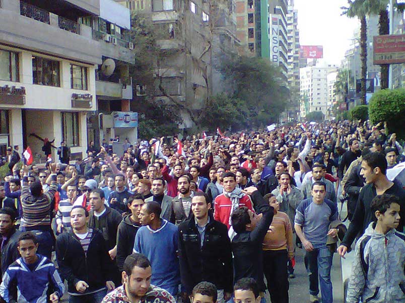
The political situation changed in Egypt with the Arab Spring of 2011. Student protests against government corruption and the lack of democratic reforms emerged with an intensity that gained the support of the Egyptian people and forced the Egyptian government to respond. Egyptian president Hosni Mubarak had been in power since 1981 after the assassination of the previous president, Anwar Sadat. President Mubarak was able to win every election for president that had been held since that time. Millions of Egyptians took to the streets in early 2011 in civil protests against the Mubarak government. Massive protests and demonstrations continued until February 11, when President Mubarak announced his resignation. The people and the government continue to search for progressive opportunities to address their issues. What started out as the Arab Spring turned into the Arab Year as all three long-term leaders in Tunisia, Libya, and Egypt were removed from positions of power.
C. The African Transition Zone
Stretching across the widest part of Africa on the southern edge of the Sahara Desert is the African Transition Zone. Known as the Sahel, meaning “border or margin,” this steppe zone is where the arid conditions of the desert north meet up with the moister region of the tropics. For thousands of years, the seasonal grazing lands of the Sahel have been home to nomadic groups herding their livestock across the zone and eking out a living held together by tradition and heritage. Changing climate conditions and overgrazing has enhanced the desertification process, and the region is slowly turning into desert. The Sahara Desert is shifting southward, altering the economic activities of the millions of people who live in its path. This desertification process has been occurring for centuries; it is not a new process. Human factors and climate change may be accelerating this process, but they did not create it.
Political stability is complicated to achieve in the African Transition Zone. The political borders established by European colonialism during the Berlin Conference of 1884 remain basically intact and create barriers that hamper the nomadic groups from traveling through the Sahel in search of grazing land for their livestock. Political boundaries now restrict movement and keep people divided and separated into national identities. The African Transition Zone is also in transition from a rural, traditional agrarian culture to a society confronting the information age and modern technology. Camel caravans that once transported goods and materials across wide expanses of desert terrain are being replaced with motor vehicles and aircraft. The many traditional groups across this zone are adapting to the conditions of the modern world but work to retain their values and traditions. Today this region is unstable, with political and cultural conflicts between the local groups and governments. The recent conflicts in Sudan are examples of the instability.
D. Sudan: Slavery and Genocide
Prior to 2011 Sudan was the largest country in Africa, comparable in size to the entire United States east of the Mississippi River. The capital city of Khartoum lies where the Blue Nile River converges with the White Nile. Khartoum’s government has a black Arab majority and follows Islam, complete with Sharia laws. The African Transition Zone crossed Sudan and separated the Arab-Muslim north from the mainly African-Christian south. There was civil war between the north and the south for decades. Before a peace agreement brokered in 2005, military soldiers from the north would raid the villages in the south, taking women and children as slaves. Though the Sudanese government denied the slave trade, thousands of Africans were owned by northern black Arabs in Sudan, and many still are. The world community has made little effort to intervene. The price for a slave in Sudan is about fifty US dollars.
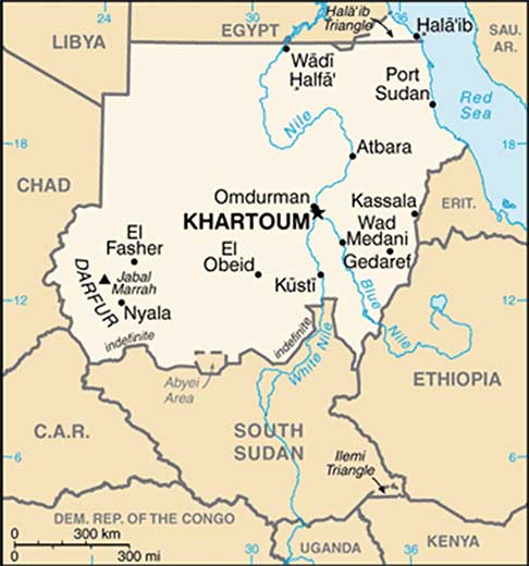
The differences in religion, ethnicity, and culture always divided southern Sudan from the north. In January 2011, the southern region of Sudan voted on a referendum that would allow the south to break away and become an independent country called the Republic of South Sudan. The new Republic of South Sudan was formalized in July of 2011. Juba is designated as the capital with talk of moving it to the city of Ramciel in the center of the country in the future. The many clans and indigenous groups make it difficult for unity and cohesiveness in the new country. Armed groups in the various states continue to cause internal division, while at the same time boundary disputes continue to be worked out with North Sudan.
In 2003, various groups in Darfur complained that the Khartoum government was neglecting them. A militia group calling itself the Janjaweed was recruited by the local Arabs to counter the resistance in Darfur. The Janjaweed began an ethnic cleansing campaign that pushed into the Darfur region, burning villages, raping women, and killing anyone who opposed them. Refugees began to flee into the neighboring country of Chad.
In this particular case, the campaign was not based on religious divisions, because both sides were Muslim. This was an ethnic conflict in that the people of Darfur are of a traditional African background and the people of northern Sudan consider themselves Arab, even though they may have dark skin. Accurate numbers have been difficult to verify, but as of 2010 an estimated 300,000 people had died in this conflict. There were more than 2.7 million refugees, many of them in Chad. Just as the government of Sudan denied the slave trade, it denies that it supports the Janjaweed. The African Union provided a modest number of peacekeeping troops before the UN stepped in to provide security. It has been up to the world community and Sudan to take more action and provide more assistance. Food, water, and care for the refugees have taxed the region’s aid and support system.
E. The African Union
Former Libyan leader Muammar Gadhafi was instrumental in the development of the African Union (AU) in the mid-1990s. The Sirte Declaration (titled after Gadhafi’s hometown of Sirte in Libya) was issued by the Organization of African Unity, which outlined the need for the creation of the AU. The AU was launched in Durban, South Africa, on July 9, 2002. Fifty-three countries formed this intergovernmental organization. The focus of the AU is on the health, education, economic development, political stability, environmental sustainability, and general welfare of the people of Africa. The organization strives to integrate the socioeconomic and political stability of its members and promote a continent-wide effort for security and peace. The AU is working to create a proper political climate, one that helps its member states engage in the global economic marketplace by negotiating international issues and policies that affect Africa.
The dominating activities of colonialism and neocolonialism (corporate colonialism) are big concerns for the AU. The AU’s objective is to bring more unity to the political and economic arena between the African countries to address the transition to a globalized world. It faces many challenges within its realm, including health care issues such as HIV/AIDS and malaria that have devastated much of Africa. The AU is working to bring political stability to countries such as Sudan and other countries experiencing civil unrest because of political turmoil or civil war, such as the Congo, Somalia, Sierra Leone, Ivory Coast, and Liberia. AU peacekeeping troops are assisting in this process. The legal issues regarding border disputes or territorial disputes such as that of Western Sahara are problems that the AU attempts to address.
In the global scale of economic and political supranationalism, the AU will be up against three main powerhouses: the European Union, the North American Free Trade Agreement, and the East Asian Community. Regions across the globe are working on trade associations to create economic networks to bring about greater cooperation and commerce between nations. The AU is one part of that network that represents a growing percentage of the world’s population and the second-largest continent on Earth.
Key Takeaways
- Three main physical features of North Africa are the Atlas Mountains, the Sahara Desert, and the Nile River. Most of North Africa’s population lives along the Mediterranean coast or along the Nile River. The ethnic majority in the Maghreb are Berber, with Arabs dominating in Egypt.
- The Maghreb centers on the Atlas Mountains, which traditionally has provided for a diversity of food production. Oil has been found in North Africa, the export of which has surpassed the export of food products.
- Europe has had a strong influence on the region, ranging from the Roman Empire, to colonial activity, to becoming a destination for immigrants looking for employment and opportunities.
- North Africa has experienced serious political conflicts. Political leaders in Tunisia, Libya, and Egypt who had been in power for decades were ousted in the Arab Spring of 2011 as people protested for economic and political reforms.
- The African Transition Zone creates the southern boundary for North Africa. This zone serves as the transition between the arid type B climates and the tropical type A climates. It is also the transition between the dominance of Islam and the dominance of Christianity and animism.
- The African Transition Zone cut through the center of Sudan and divided the country along religious and ethnic distinctions. Civil war has been waged in the south and in the Darfur region, which has split the country into separate regions. South Sudan became an independent country in 2011.
10.4 Israel and Its Neighbors
Learning Objectives
- Summarize how the region of Palestine has evolved into the current Jewish State of Israel. Identify and locate the territories that have been annexed to Israel over the years.
- Understand the division between the West Bank and the Gaza Strip and the Jewish State of Israel. Outline the complications of the one-state and two-state solutions to this division.
- Describe the differences between the governments of Jordan and Syria.
- Outline the political arrangements of the government leadership positions in Lebanon.
A. The State of Israel
At the center of the Middle East, on the shores of the Mediterranean in the Levant (the area bordering the eastern Mediterranean Sea), lies the country of Israel. Israel is bordered by Lebanon to the north, Syria and Jordan to the east, and Egypt to the south. Covering an area of only 8,522 square miles, Israel is smaller than the US state of Massachusetts. The coastal region, which has a moderate type C Mediterranean climate, receives more rainfall than the dry interior and the Negev Desert in the south, both of which have arid type B desert climates. The Sea of Galilee, also called Lake Kinneret or the Sea of Tiberias, is a major fresh water supply. The Jordan River flows from the Sea of Galilee to the Dead Sea. The Dead Sea is 1,300 feet below sea level, so it has no outlet. Over time, salts and minerals have built up, creating an environment that does not support fish or aquatic life. South of the Negev Desert is the Gulf of Aqaba, which provides access to the Red Sea for both Israel and Jordan. Israel does not have substantial oil resources but has a potential for natural gas in offshore locations along the Mediterranean Sea.
Though most of the population in the Middle East is Islamic, there are exceptions, such as in Israel, which has a Jewish majority. Israel was established in 1948. Before that time, the country was called Palestine. The region went through a series of tumultuous transitions before it became the nation of Israel. Before 1948, most people in Palestine were called Palestinians and consisted primarily of Arab Muslims, Samaritans, Bedouins, and Jews. Most Jewish people were dispersed throughout the world, with the majority in Europe
and the United States.
B. The Division of Palestine
Palestine was a part of the Turkish Ottoman Empire before the end of World War I. Britain defeated Turkish forces in 1917 and occupied Palestine for the remainder of the war. The British government was granted control of Palestine by the mandate of the Versailles Peace Conference in 1919 at the end of World War I. Britain supported the Balfour Declaration of 1917, which favored a Jewish homeland. The British Mandate included Palestine and Transjordan, the area east of the Jordan River, which was later renamed Jordan.
Between 1922 and 1947, during British control, most of the population of Palestine was ethnically Arab and followed Islam. In 1922, Jews made up less than 20 percent of the population. The Jewish settlements were mainly along the west coast and in the north. Jewish people from other countries—including Jews escaping German oppression in the 1930s—migrated to the Israeli settlements. Palestine was turned over to the control of the newly created United Nations (UN) in 1945 at the end of World War II.
The United Nations Special Committee on Palestine (UNSCOP) was created by the UN in 1947. To address the Palestine region, UNSCOP recommended in its UN Partition Plan for Palestine that Palestine be divided into an Arab state, a Jewish state, and an international territory that included Jerusalem. About 44 percent of the territory was allocated to the Palestinians, who consisted of about 67 percent of the population, which was mainly Arab. Approximately 56 percent of the territory was allocated to the minority Jewish population, who made up about 33 percent of the population. The city of Jerusalem was to remain under the administrative control of the UN as an international city. The Jewish State of Israel was officially recognized in 1948. The Palestinians, who were a majority of Israel’s total population at the time and who owned about 90 percent of the land, denounced the agreement as unacceptable.
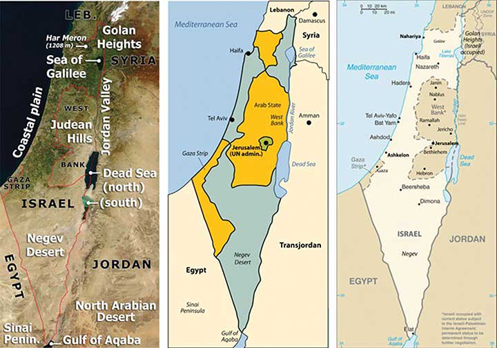
Israeli leaders accepted the UN plan and on May 14, 1948 declared Israel’s independence within those boundaries. Palestine’s Arab neighbors—Syria, Saudi Arabia, Lebanon, Iraq, and Egypt—sided with the Arab Palestinians and declared war on Israel, invading the very next day. The war did not end favorably for the Arabs. With support and aid from Britain and the US, Israel defeated the attacking Arab armies and took control of a larger portion of the land, including some of the land designated by the UN as a portion of the Arab state. Over 750,000 Palestinians living in the Jewish-controlled regions of Israel were forced out of their homes and into refugee camps. The result of the 1948 Arab-Israeli War (also called the First Arab-Israeli War), was that Israel established itself as an independent country with a larger territory than called for in the UN Partition Plan.
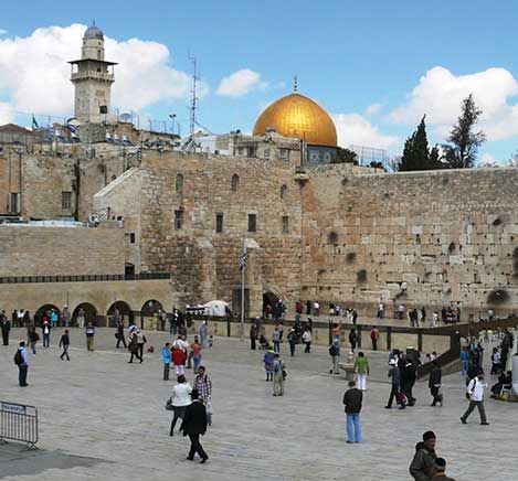
By 1967, the Arab armies had regrouped and were willing to attack Israel again. The 1967 War was short lived, lasting only six days, from June 5 through 10, and is hence often called the Six Day War. The Arab armies were devastated once again, and Israel gained even more territory. Israel took the Sinai Peninsula and the Gaza Strip from Egypt, the Golan Heights from Syria, and the West Bank from Jordan. The entire city of Jerusalem came under Israeli control, including the eastern portion that includes the old walled city and important features such as the Temple Mount, the site of the original Jewish temple on Mt. Moriah. The 1967 war solidified the control of the region of Palestine under the Israeli government and placed Israel at greater odds with its Arab neighbors. Syria wanted Israel to return the Golan Heights, which has a strategic military advantage in overlooking northern Israel, and Egypt wanted Israel to return control of the Sinai Peninsula.
Egypt and Syria attacked Israel again on October 6, 1973, which was Yom Kippur (literally, “Day of Atonement” in Hebrew), the most solemn holiday in the Jewish religion, and thus this is known as the Yom Kippur War. The Israeli army counterattacked, driving the Syrians out and the Egyptian army back across the Suez Canal. After a few weeks of conflict, a cease fire was agreed upon.
In 1978, Israeli Prime Minister Menachem Begin and Egyptian President Anwar Sadat were invited to Camp David, Maryland, by US President Jimmy Carter. Israel and Egypt signed the Camp David Accords, an agreement which led to the 1979 Egypt-Israeli Peace Treaty. Egypt agreed to officially recognize the State of Israel and to not invade Israel again. Israel agreed to return the Sinai Peninsula to Egypt; the peninsula was returned in 1982. Each participant in the accord won the Nobel Peace Prize. This was the first peace treaty between an Arab state and the state of Israel, and the first time an Arab country officially recognized Israel’s right to exist as an independent state. Since Egypt was one of the most prominent Arab countries and had been involved in all prior Arab-Israeli wars, this was monumental geopolitically.
In 1980, Israel passed the Jerusalem Law, which stated that greater Jerusalem was Israeli territory and that Jerusalem was the eternal capital of the State of Israel. The UN rejected Israel’s claim on greater Jerusalem, and few if any countries have accepted it. Israel moved its capital from Tel Aviv to Jerusalem to solidify its claim on the city even though most of the world’s embassies remain in Tel Aviv. The move of the capital was designed to create a forward capital, the purpose of which is usually either to lay claim to or protect a nation’s territory or to spur the development of the country. In this case, it was to lay claim to valuable territory. In 1981, Israel formally annexed the Golan Heights, making it officially part of the country and signaling an unwillingness to ever r
eturn it to Syria.
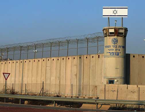
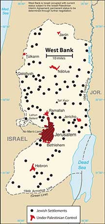
Palestinians were left with only the regions of the Gaza Strip and the West Bank, which is controlled by the Israeli government and is subject to Israel’s national jurisdiction. As of 2010, about 1.5 million Palestinians lived in the Gaza Strip and 2.5 million lived in the West Bank. A number of cities in the West Bank and Gaza Strip have been turned over to the Palestinian Authority (PA) for self-governing. The PA was established between the Palestine Liberation Organization (PLO) and the Israeli government to administer internal security and civil matters. The PLO and the PA are two separate entities. The PLO is the internationally recognized governing body of the Palestinian people. It is legitimately recognized by the UN to represent the area known as Palestine in political matters. There are two main political parties within the PLO: Hamas and Fatah. The Hamas party is the strongest in the Gaza Strip, and the Fatah party is more prominent
in the West Bank.
C. The Palestinians, Israel, and Possible Solutions
The future of the West Bank and Gaza Strip has been the focus of talks and negotiation for decades. There are various ways to approach this issue; a one-state solution and a two-state solution have been proposed. The one-state solution proposes the creation of a fully democratic state of Israel and the integration of all the people within its borders into one country. Integration of the Gaza Strip and the West Bank into the Jewish State of Israel is part of this plan; in other words, “Take the walls down and create one state.” Many Palestinians support the one-state solution, but most of the Jewish population does not. Family size is much larger in the Palestinian side, so it would be only a matter of time before the Jewish population would be a minority population and would not have full political control with a democratic government. To have the Jewish State of Israel, the Jewish population needs to keep its status as the majority.
In a two-state solution, Palestinians would have their own nation-state, which would include the Gaza Strip and the West Bank. The rest of former Palestine would be included in the Jewish State of Israel. The two-state concept (Israel and a Palestinian state) has been proposed and supported by a number of foreign governments, including the United States. Implementation of a two-state solution is, of course, not without its own inherent problems. At the present, the West Bank and Gaza Strip are subjects under the Jewish State of Israel without full political or economic autonomy.
Parties to the negotiations have acknowledged that the most likely solution is to create a Palestinian state bordering Israel. However, it is not clear how to make this happen. Palestine is now divided between the Jewish State of Israel (with 7.3 million people) on one side and the Palestinians (with 4.0 million people) in the West Bank and the Gaza Strip on the other side. About 75 percent of Israel’s population of 7.3 million people are Jewish, and about 25 percent are Arab. Travel between Israel and the Palestinian areas is heavily restricted and tightly controlled. A high concrete and barbed wire barrier separates the two sides for much of the border. The West Bank provides fresh water used on the Israeli side for agriculture and industrial processes. The industries also employ Palestinians and support
them economically.
Jewish people from various parts of the world continue to migrate to Israel, and the Israeli government continues to build housing settlements to accommodate them. Since the West Bank is under Israeli jurisdiction, many of the new housing settlements have been built in the West Bank. The Palestinians who live there strongly oppose the settlements. In 1977, only about five thousand Jews lived in the West Bank settlements. As of 2010 there were more than two hundred thousand. The Palestinians argue that if they were to have their own nation-state, then the Jewish settlements would be in their country and would have to be either resettled or absorbed. Israel responds by indicating that the two-state solution is indefensible because the Jewish settlements in the West Bank cannot be protected if the West Bank is separated from Israel.
The issues in Israel are complicated. After a series of wars and considerable negotiations, the central problems remain: Jews and Palestinians both want the same land, both want Jerusalem to be their capital, and neither can find a compromise. Support for the Jewish State of Israel has primarily come from the US and from Jewish groups external to Israel. There are more Jews in the United States than there are in Israel, and the US Jewish lobby is powerful. Israel has been the top recipient of US foreign aid for most of the years since 1948. Through charitable donations, US groups provide Israel additional billions of dollars annually. Foreign aid has given the Jewish population in Israel a standard of living that is higher than the standard of living of many European countries.
The problems between Israel and Palestinians are far from settled. The region has plenty of interconnected concerns. Israel has nuclear weapons, and Iran has worked at developing nuclear weapons. US involvement in the region has heightened tensions between Iran and Israel. Oil revenues are driving the economies of most of the Arab countries that support the Palestinians. Oil is an important export of the region, with the United States as a major market. The difficulties between Israel and the Palestinians continue to fuel the conflict between Islamic fundamentalists and Islamic reformers. Some Islamic groups have accepted Israel’s status as a country and others have not. The Israel-Palestinian problem drives the geopolitics of the Middle East.
D. Jordan
North of the Arabian Peninsula are three Arab states that surround Israel: Jordan, Syria, and Lebanon. Each country possesses its own unique physical and cultural geography. The country of Jordan was created through the British Mandate after World War I, when Britain defeated the Turks in Palestine. The area east of the Jordan River became the modern country of Jordan in 1946. From 1953 to 1999, during the most volatile period of the region, the country was ruled by a pragmatic leader, King Hussein, who was able to skillfully negotiate his way through the difficult relationship with Israel and yet keep his country stable. When Palestine was divided by the UN to create the State of Israel, the region of Jordan received more than a million Palestinian refugees from the West Bank and Israel. Refugees make up a large portion of the more than six million people who live in Jordan today; about a half million refugees from the US war in Iraq are included in that total.
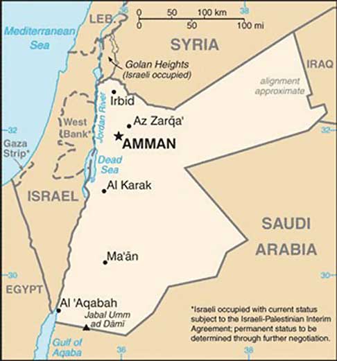
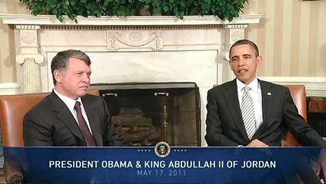
Jordan is not large in physical area. Natural resources such as oil and water are not abundant here, and the country often has to rely on international aid to support its economy. Inflation, poverty, and unemployment are basic issues. The government of Jordan is a constitutional monarchy. King Hussein’s son ‘Abdullah II took power after the king’s death in 1999. Economic reforms were implemented by King ‘Abdullah II to improve the long-term outlook of the country and raise the standard of living for his citizens. The king allowed municipal elections to be conducted, which allowed for 20 percent of the positions to be dedicated to women candidates. Parliamentary elections were held by a democratic vote.
Jordan has demonstrated how a country with few natural resources in a volatile region of the world can proceed down a progressive path despite difficult circumstances. Jordan has developed a positive trade relationship with Europe and the United States while at the same time working with its Arab neighbors to access oil and to maintain a civil state of affairs. Jordan is not without its challenges but has managed to confront each issue yet retain a sense of stability and nationalism.
E. Syria
The strategically located country of Syria is at the center of the Middle East’s geopolitical issues. Syria gained its independence from the French Mandate in 1946, the same year as Jordan. Syria has strived to work out and stabilize its political foundation. In a move to create greater Arab unity in the realm, Egypt and Syria joined forces and created the United Arab Republic in 1958. This geopolitical arrangement lasted until 1961, when the partnership was dissolved. Syria returned to its own republic. The Arab Socialist Baath Party gained strength, and in 1970 Hafiz al-Assad, of the Alawite minority (an offshoot branch of Shia Islam making up about 10 percent of the Syrian population), took over leadership in a coup that stabilized the political scene. It was during this era that the Golan Heights was lost to Israel in the Arab-Israeli War of 1967. This strategic geographical location is a point of contention in the peace negotiations between Syria and Israel.
Hafiz al-Assad served as the leader of Syria for twenty-nine years without having been democratically elected to the office by the people. His son Bashar took the reins of leadership after Hafiz died in 2000. The Alawite sect held power in Syria through the Assad family under military control. Syria has been accused of using its military power to influence conditions in Lebanon, where it brokered a peace deal in its civil war (1975–1990). Syria has also been accused of supporting the anti-Israel groups headquartered in Lebanon.
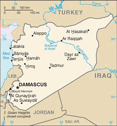
Syria is located in an ancient land with a long history of empires and peoples. The region of Syria was once part of the cradle of civilization that sprung up in Mesopotamia. Damascus claims to have been continually inhabited longer than any other capital city on Earth. The largest city and the center of industrial activity is Aleppo, which lies in the north of Syria. Syria’s physical area is slightly larger than the US state of North Dakota. Overall, Syria’s climate is characterized as an arid type B climate; some regions receive more rain than others. The western region, because it borders the Mediterranean Sea, is an area that receives more rainfall. The additional rainfall translates into extensive agricultural production. The northeast area of Syria is also productive agriculturally through water resources provided where the Euphrates River cuts through the country. Oil and natural gas have been the country’s main export products. The petroleum reserves are being depleted, and few new fields are being developed. Eventually, the wealth generated by the sale of petroleum reserves, which are finite resources, is projected to diminish, even as the population continues to increase.
The Syrian government has exerted strict control over the economy. The country will face serious economic issues in the future. There is a high rate of unemployment. Because oil production has not been increasing, the government has been forced to take on additional national debt. The arid climate and the need to supplement agriculture production have placed additional pressure on precious fresh water supplies. The Euphrates River provides fresh water, but it originates in Turkey, where large dams restrict the flow. Water rights for the region are therefore an issue. One third of Syria’s population is under the age of fifteen, which indicates a rapid population growth pattern that will tax future resources at an increasing rate. In 2010, Syria had about twenty-two million people. The country holds political significance; its strategic location between Iraq and Israel makes it is a vital player in any solution for lasting peace in the Middle East.
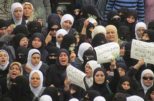
Syria experienced protests and demonstrations similar to those that swept through North Africa in the Arab Spring of 2011. Citizens expressed dissatisfaction with the government because of the lack of democratic reforms, high unemployment, and the loss of civil rights. Student protests escalated to massive citizen demonstrations that emerged in various Syrian cities in the spring of 2011. The government cracked down on protesters, killing some. After extensive demonstrations on March 15, the government arrested more than three thousand people. Hundreds were killed in violent clashes between the people and government security forces. The lack of democratic processes by President Bashar al-Assad’s government continued to prompt protests and demonstrations in Syria, eventually resulting in armed conflict between protesters and the Syrian government and the start of civil war. As of 2017, the Syrian Civil War that began in 2011 continues.
Key Takeaways
- The current Jewish State of Israel was recognized in 1948. Before this time, the region was called Palestine and the people who lived there were called Palestinians.
- Victorious in war against their Arab neighbors, Israel acquired the Golan Heights, the West Bank, the Gaza Strip, and the city of Jerusalem. The West Bank and the Gaza Strip are considered Palestinian territory. Two plans have been proposed to address the division but have not been agreed upon.
- Jordan is a constitutional monarchy led by King Abdullah II, who has worked to implement reforms to maintain a country that has few natural resources.
- The government of Syria is led by Bashar al-Assad, a member of a minority ethnic group called the Alawites. Assad and his father have ruled Syria for more than forty years under a state of emergency. Civil war has raged since 2011, resulting in tens of thousands of deaths and creating millions of refugees.
10.5 The Arabian Peninsula
Learning Objectives
- Summarize the physical and cultural features of the Arabian Peninsula.
- Describe the economy and government of Saudi Arabia.
- Outline women’s rights and circumstances in Saudi Arabia.
A. Overview
The Arabian Peninsula is a desert environment surrounded by saltwater bodies. The Persian Gulf, the Arabian Sea, and the Red Sea border the peninsula on three sides. Arid type B climates dominate the region. Saudi Arabia only receives an average of four inches of precipitation per year. The southern portions of the peninsula are some of hottest places on Earth. Summer temperatures can reach more than 120 ºF. In the south is the Rub’ al-Khali (Empty Quarter), which is mainly desert and comprises about 25 percent of Saudi Arabia. It is extremely dry and virtually uninhabited, though oil discoveries have brought temporary settlements to the region. There are no natural lakes or major rivers on the peninsula. Agricultural activity is dependent on the availability of water by rainfall, underground aquifers, oases, or desalinization of seawater.
Most of the people living on the peninsula are Arabs, and most of the peninsula’s countries are ruled by monarchs who rely on oil revenues to gain wealth. Minerals are mined in the mountains that dominate the peninsula’s western and southern regions. The highest peaks reach more than twelve thousand feet in elevation in northern Yemen. Of the countries on the peninsula, Yemen has the fewest oil resources and has had the sole democratically elected government. Saudi Arabia dominates the region in size and in oil resources. Islam, the major religion, infiltrates all aspects of
Arab culture.
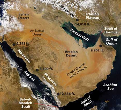
Saudi Arabia
The holy cities of Medina and Mecca are in Saudi Arabia, the birthplace of Islam. Islam first united the many traditional groups of Arabia with religion and then with the Arabic language. The region was further united after 1902, when Abdul Aziz Al-Sa‘ud and his followers captured the city of Riyadh and brought it under the control of the House of Sa‘ud. In 1933, the lands under the control of the king were renamed the Kingdom of Saudi Arabia. Saudi Arabia is an absolute monarchy. In 1938, US oil corporation Chevron found large quantities of oil in the region, which has sustained the royal family ever since. Saudi Aramco (originally the Arabian-American Oil Company, or Aramco for short) is the state-run oil corporation. Controlling about one-fifth of the world’s known oil reserves, the Saudi royal family claims considerable power.
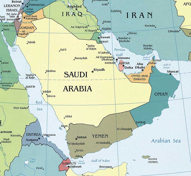
The Saudi royal family gave safe haven to thousands of Kuwaitis, including the emir and his family, during the First Persian Gulf War (1991). Saudi Arabia allowed US and Western military forces to use bases on its soil during Operation Desert Storm. Acquiescence to non-Muslims operating military bases on the same soil as the holy cities of Mecca and Medina gave extremist groups a reason to engage in terrorist activities. Out of the nineteen hijackers in the 9-11 attack in New York, sixteen were from Saudi Arabia. The Saudi government has been forced to step up its efforts against terrorism and domestic extremist groups.
The entire economy of Saudi Arabia is based on the export of oil, and more than 20 percent of the known oil reserves in the world are located in Saudi Arabia. The country is a key member of the Organization of Petroleum Exporting Countries (OPEC) and has been the world’s number one oil exporter. Millions of foreign workers in the petroleum industry make up a vital component of the country’s economy.
A high rate of population growth has been outstripping economic growth in Saudi Arabia. In 2010, more than one-third of the population was younger than fifteen years old, and family size was about 3.8 children. The unemployment rate is high, and there is a shortage of job skills in the workforce. The government has been working to shift its focus away from a petroleum-based economy and increase other economic opportunities; it plans to heavily invest in the necessary infrastructure and education to diversify its economy.
Saudi Arabia has made several efforts to move forward and put the country more in line with globalization efforts that are modernizing the other Persian Gulf States. The World Trade Organization accepted Saudi Arabia as a member in 2005. In 2008, the king implemented the initiative for interfaith dialogue in an effort to address religious tolerance and acceptance. The first woman was appointed to the cabinet, and municipal councils held elections for its members.
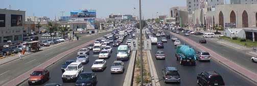
Saudi Culture
The royal family and most of the people in Saudi Arabia are Sunni Muslims. The country has a strong fundamentalist Islamic tendency. The law of the state is strict and supports conservative Islamic ideals. The Wahhabi branch of Sunni Islam has a major influence on culture. Activities such as gambling, alcohol consumption, and the promotion of other religions are outlawed. Alcohol and pork products are forbidden in accordance with Islamic dietary laws. Movie theaters and other Western-style productions are prohibited but can be found in areas where workers from other countries live in private compounds. Though movie theaters are restricted, movies on DVDs are not prohibited and are widely available. The dress code in Saudi Arabia strictly follows the Islamic principles of modesty. The black abaya (an article of clothing that looks like a cloak or robe) or modest clothing is appropriate for women. Men often wear the traditional full-length shirt and a headcloth held in place by a cord.
In Saudi Arabia, human rights organizations, legal associations, trade unions, and political parties are banned. The country maintains a tight censorship of all local media. The press is only allowed to publish what the government permits it to report.
Communication with foreigners, satellite media, and Internet access are highly controlled. Those who speak out against the government can be arrested or imprisoned.
The Sharia is the basic criminal code in Saudi Arabia, along with whatever law is established by the king. A wide range of corporal and capital punishments—from long prison sentences to amputations (arm or foot), floggings, and beheadings—are proscribed for legal or religious offenses. Trials are most often held in secret without lawyers. Torture has been used to force confessions that are then used to convict the accused. Torture techniques—including the use of sticks, electric shocks, or flogging—can be applied to children and women as well as men. Executions are usually held in a public place every Friday.
Role of Women
Men hold the dominant roles in Saudi society. Under strict Islamic law, women do not have the same rights as men, so Saudi women do not have the opportunities that women in many Western countries have. For example, it is not customary for a woman to walk alone in public; traditionally, she must be accompanied by a family member so as to not be accused of moral offences or prostitution. Themutawa’een (religious police) have the authority to arrest people for such actions. The punishment could be as many as twenty-five days in prison and a flogging of as many as sixty lashes.
As of 2011, the following restrictions have been made on women:
- Women are not allowed to drive motor vehicles.
- Women must wear modest clothing such as the black abaya and cover their hair.
- Women can only choose certain college degrees. They cannot be engineers or lawyers, for example.
- Women cannot vote in political elections.
- Women cannot walk in a public spaces or travel without a male relative.
- Women are segregated from men in the workplace and in many formal spaces, even in homes.
- Women need written permission from a husband or father to travel abroad.
- Marriages can be arranged without the woman’s consent, and women often lose everything in a divorce.
Saudi Arabia is a country steeped in tradition based on the heritage of its people. However, as the forces of globalization seep into the fabric of society, some of these traditions are evolving and changing to adapt to the times and to a more open society. Women are asserting themselves in the culture, and many long-standing traditions are starting to break down. Saudi Arabia is an example of how Islamic fundamentalism is being challenged by modernity and democratic principles.
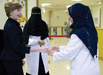
Key Takeaways
- The Arabian Peninsula is a desert region. The Rub’ al-Khali (Empty Quarter) provides an example of desert extremes. The mountains along the western and southern edges receive the most rainfall. There are no rivers or major lakes on the peninsula. Water, a resource that is vital to human activity, is scarce throughout the region.
- The export of oil and natural gas is what drives the economies of the region. Many of the states are working to diversify their economies with banking, free-trade zones, and even tourism.
- Family size varies widely in the region, from more than 4.5 children per family in Yemen and 3.8 in Saudi Arabia, to around 2.5 in the progressive Gulf States of Qatar, the UAE, and Bahrain. Women’s rights and opportunities have an inverse relationship with family size; that is, when women’s rights and opportunities increase, family size usually decreases. In the Gulf States, the smaller countries in land area are more open to promoting women’s rights and responsibilities in the public and private sectors.
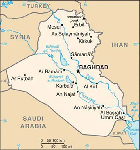
10.6 Iraq, Turkey, and Iran
Learning Objectives
- Summarize Iraq’s role in the Persian Gulf War and the Iraq War in 2003.
- Understand how Iraq is divided ethnically and by the branches of Islam.
- Explain why Turkey wants to be a member of the European Union (EU) and why it has not been accepted.
- Outline Iran’s physical geography and how it has used natural resources for economic gain.
- Determine why young people might be dissatisfied with the policies of the Iranian government.
A. Iraq
Iraq lies in the Fertile Crescent between the Tigris and Euphrates Rivers, where the ancient civilizations of Mesopotamia were established. Ancient cities such as Nineveh, Ur, and Babylon were located here. Present-day Iraq and Kuwait were established out of the British Mandate territory gained following Britain’s defeat of the Turkish Ottoman Empire. Britain established straight-line political boundaries between Iraq and Jordan, Syria, and Saudi Arabia. These types of boundaries are called geometric boundaries because they do not follow any physical feature. In 1961, when Britain withdrew from the region, the emir controlling the southern region bordering the Persian Gulf requested that Britain separate his oil-rich kingdom as an independent country. This country became Kuwait, and the rest of the region became Iraq. After a series of governments in Iraq, the Baath party came to power in 1968, paving the way for Saddam Hussein to gain power in 1979.
Iran-Iraq War (1980–88)
In 1980, a disagreement arose over the Shatt al-Arab waterway in the Persian Gulf on the border between Iraq and Iran, and the feud led to war between the two countries. The people of Iran are not Arabs; their ethnic background is Persian. Most Iranians are Shia Muslims. Saddam Hussein and his Baath party were ethnically Arabs and were Sunni Muslims. Ethnic and religious differences thus fueled the conflict. The war ended in 1988 without anyone declaring a victory. The Iran-Iraq War resulted in more than a million casualties and cost more than one hundred billion dollars. Before the war, the Iranian government had been taken over by Islamic fundamentalists who opposed the US intervention in the region; therefore, in the Iran-Iraq War, the United States supported Hussein and provided him with industrial
supplies and materials.
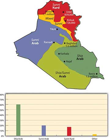
The Persian Gulf War (1990–91)
After the Iran-Iraq War, Saddam Hussein looked to Kuwait to gain new oil wealth and expand access to the Persian Gulf. Hussein accused Kuwait of slant drilling oil wells along the Iraqi border and removing oil that was legally Iraq’s. It was common knowledge that both sides engaged in this practice, but it was the excuse Hussein needed to invade Kuwait.
In 1990, the Iraqi military invaded and occupied Kuwait. Though the world community opposed this action, it was not until Hussein nationalized all the oil assets of the international oil corporations that resistance was organized. Under the leadership of US president George H. W. Bush, the UN organized a military coalition to remove Hussein from Kuwait. On January 16, 1991, Operation Desert Storm , which was a massive air campaign, began. After forty-five days of fighting, Iraq was overwhelmingly defeated and its military was ousted from Kuwait.
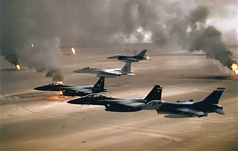
When it became evident that Hussein would lose Kuwait, his forces dynamited all the oil facilities and set all the oil wells in Kuwait on fire. His position was that if he could not have the oil, then nobody would. This was one of the worst environmental catastrophes regarding oil on record. Oil flowed into the Persian Gulf and covered the water’s surface up to three feet thick. Most mammals, birds, and organisms living on the water’s surface died. Oil flowed out onto the desert sand into large petroleum lakes. The air pollution caused by burning oil wells dimmed the sun and caused serious health problems.
Ethnic and Cultural Divisions
To keep Iraq from breaking apart after Operation Desert Storm, coalition forces allowed Hussein to remain in power. Ethnically and religiously, Iraq is divided into three primary groups that generally do not get along. Sunni Arabs dominate central Iraq in a region often referred to as the Sunni Triangle, which includes the three cities of Baghdad, Tikrit (Hussein’s hometown), and Ramadi. Sunnis were the most loyal to the Hussein government. Southeastern Iraq is dominated by Arabs who follow the Shia division of Islam, which is also followed by most of Iran’s population. A group that is ethnically Kurdish and follows the Sunni division dominates northern Iraq. Kurds are not Arabs or Persians; rather, they originated from somewhere in northern Europe centuries ago with their own religion, language, and customs. Many have converted to Islam.
Hussein was a Sunni Muslim Arab, and when he was in power, he kept the Sunni Kurds and Shia Arabs in check. He used chemical weapons on the Kurds during the Iran-Iraq War. In 1988, he used chemical weapons on the Kurdish town of Halabja and killed about 10 percent of the eighty thousand who lived there. Thousands of Kurds died in other attacks, and thousands more continue to suffer serious health effects. After Operation Desert Storm, Hussein pushed the Kurds north until the UN and the United States restricted him at the thirty-sixth parallel, which became a security zone for the Kurds. The Arab Shia population in the south often clashed with Hussein’s military in an attempt to gain more political power, and Hussein subjected them to similar harsh conditions and treatment.
The Kurds are the largest nation of people in the world without a country. About twenty-five million Kurds live in the Middle East, and most—about fourteen million—live in Turkey. About eight million Kurds live in Iran, about seven million live in Iraq, and the rest live in neighboring countries. At the 1945 conference of the UN, they petitioned to have their own country called Kurdistan carved out of Iran, Iraq, and Turkey, but they were denied. Israel was approved to become a state at the same UN conference.
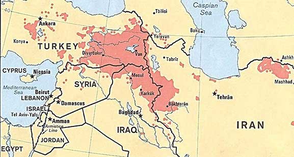
The Iraq War (2003-11)
After the September 11, 2001, attack on the United States, there was a renewed interest in weapons of mass destruction (WMD). Knowing that Hussein had used chemical weapons on the Kurds, the Iranians, and the Shia, there was a concern he would use them again. UN Weapons inspectors in Iraq never could confirm that Hussein retained WMD. They had been destroyed, moved out of Iraq, or hidden. US president George W. Bush decided to invade Iraq in 2003 to remove Hussein from power. In the invasion, Hussein’s two
sons were killed and Hussein
was captured.
The US invasion of Iraq brought about the removal of the Baath Party from power and Iraq came under a military occupation by a multinational coalition. An Iraqi Interim Government was formed that assumed sovereignty in 2004. A new constitution was drafted and approved by vote of the Iraqi people. Elections were held and a new government was formed under the newly drafted constitution. Occupying troops continued to remain as the country struggled to adapt to the reforms. Insurgencies developed that brought about an increase in violence that peaked in about 2007. By 2010, the combat operations by occupying troops were ending and the country worked to sustain stable political conditions. Under an agreed upon mandate all combat troops withdrew by the end of 2011. A number of US troops remain in Iraq in an advisory capacity.
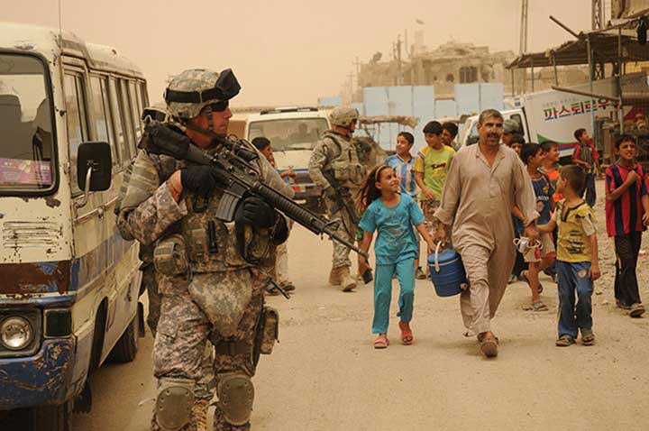
Resources and Globalization
In geographic terms, the Persian Gulf War and the Iraq War were wars over resources—namely, oil. Wars have historically been fought over territory and resources. When the United States invaded in 2003, Hussein was contracting billions of dollars’ worth of projects to oil companies in France, Russia, and China. Other support projects were contracted out to other European countries. When the United States invaded, the contracts with were summarily canceled, and British and US oil contractors took over the projects.
Iraq is an example of the second wave of globalization. Neocolonialism has been the dominant force in Iraq’s economy since before the Persian Gulf War. Industrialization requires high energy demands; therefore, the industrialized countries of the world consume energy on a massive scale. Iraq is not a core economic country, but it holds vast petroleum reserves, making it vulnerable to exploitation by industrialized core countries. It is interesting to note that the Persian Gulf War, initiated in response to Iraq’s invasion of Kuwait, can be traced directly to globalism. It was Britain that established the straight-line borders separating Kuwait and Iraq. The war over the control of Kuwait in 1991 was a war over the control of resources, just as the ongoing competition between Sunni Muslims and Shia Muslims, for example, is a competition for the control of political power or resources and not a competition related to ethnic principles.
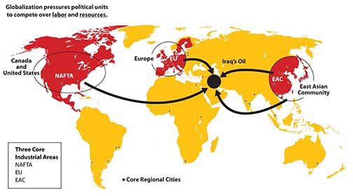
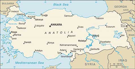
B. Turkey
Turkey is the only remaining country of the vast Ottoman Empire, which ruled the region for over six hundred years (1299–1923). When the empire was at its peak in the sixteenth and seventeenth centuries, it controlled parts of Europe, North Africa, the Middle East, and Arabia. Located on the Bosporus—the straits that connect the Black Sea with the Mediterranean Sea—the ancient city of Constantinople was the capital of the Ottoman Empire. Called Istanbul today, this city is the largest in Turkey, but it is not the current capital. Turkey moved its capital to Ankara on the Anatolian Plateau, which is centrally located in Turkey.
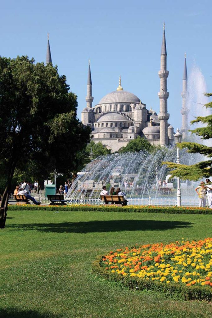
Turkey has a small portion of land on the western side of the Bosporus to claim its connection to Europe. Most of Turkey is a part of the Asian continent, and Turkey has often been referred to as Asia Minor. Mountains on Turkey’s eastern border with Armenia include Mount Ararat, which is the highest peak in the country at 16,946 feet in elevation. Legend has it that Mount Ararat was the resting place of Noah’s ark. The people of Turkey are neither Arab nor Persian; they are Turkish and speak the Turkish language. As much as 90 percent of the Turkish population is Sunni Muslim, which is similar to many of the other Muslim countries in the Middle East.
Turkey is a secular state with a democratically elected political leadership. To maintain its democracy, it has had to deal with Islamic fundamentalists, who often have supported a shift to an Islamic religious state. Turkey has also had to negotiate with its neighbors, Syria and Iraq, over water rights to the Tigris and Euphrates Rivers, which originate in Turkey but flow through the other countries. As an upstream state, Turkey has built dams on these rivers, much to the dismay of its downstream neighbors, who want to use
more of the water.
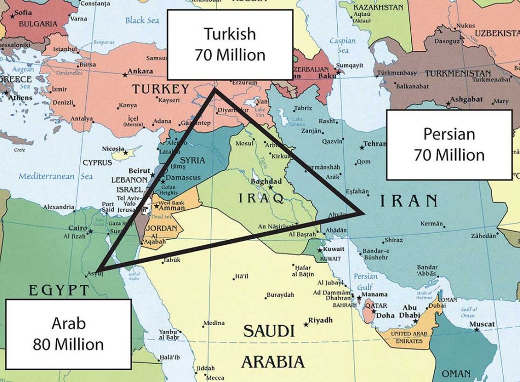
C. Iran
Iran covers a physical area larger than the US state of Alaska. It is a land of mountains and deserts: Iran’s central and eastern regions are mainly desert with few inhabitants, and the northern and western regions of the country are mountainous. The Elburz Mountains in the north around the Caspian Sea reach as high as eighteen thousand feet in elevation near the capital city of Tehran. The Zagros Mountains run along the border with Iraq and the Persian Gulf for more than nine hundred miles and can reach elevations greater than fourteen thousand feet. Similar to the Atlas Mountains in the Maghreb, Iran’s mountains trap moisture, allowing minor agricultural activities in the valleys. Most of Iran’s population lives in cities along the mountain ranges. Qanats—systems of shafts or wells along mountain slopes—bring water from the mountains to the valleys for irrigation and domestic use.
Persian Empire to Islamic Republic
Iran was once the center of the Persian Empire, which has its origins as far back as 648 BCE, and the country was called Persia until about 1935. The Ethnic Triangle of the Middle East consists of Persians in Iran, Turks in Turkey, and Arabs in Egypt. Most of the seventy million people in Iran are Persian. Iran has a long history with the ancient Persian Empire and the various conquering armies that followed it. During the rise of Islam, Iran had major contributions to the arts, mathematics, literature, philosophy, and science. The highly advanced carpet-weaving traditions from centuries past are but one example of the advancements in design and the technical expertise of the people.
Since the Iranian Revolution of 1979, Iran has been an Islamic state with an ayatollah as the Supreme Leader. An ayatollah is a high-ranking Shia cleric that is an expert in the Islamic faith and the Sharia (Muslim code of law based on the Koran). Approximately 90 percent of Iran’s population follows the Shia
division of Islam.
Political Challenges
On the international front, Iran’s leadership has indicated a drive to develop nuclear weapons and use them against Israel, which has caused concern in the global community. The government of Iran does not recognize the legitimacy of the nation of Israel. Iran is similar to Saudi Arabia in its restrictions of civil rights. A number of countries, including the United States, have placed trade sanctions against Iran regarding any materials associated with nuclear weapons or missiles. The US sanctions extend to an almost total trade embargo against Iran stemming from the 1979 revolution.
Open protests expressing a need for change have periodically erupted in the streets of Tehran. Ultimately, protesters are seeking personal freedoms and a more open society. The Arab Spring of 2011 was a phenomenon that spread across North Africa, the Arabian Peninsula, and the Middle East. Iran was not immune from the impact of the protests and demonstrations that occurred in their neighboring countries, but Iran was different. First of all, Iranians are not Arab but Persian in their ethnicity. Their history and heritage creates a distinct identity that separates them from the rest of the region. Many Iranian citizens want the same outcomes that the protesters and demonstrators wanted in the countries experiencing the Arab Spring revolutions. The difference is that Iranians have been demonstrating and protesting issues with their government in the years before 2011. Political tensions in Iran have been high since the 2009 elections and even earlier. During the 2009 election in Iran, students and other individuals used the Internet, Twitter, and cell phones to organize a massive protest against the current president and in support of opposition candidates. The demonstrations were called the Twitter Revolution.
Iran is at a crossroads in the conflict between conservative Islamic fundamentalists and Islamic reformers. The government of the Islamic state is controlled by Muslim clerics who tend to be more conservative in their rulings, but the young people are mainly on the side of the democratic reformers. Young people are becoming more familiar with Western culture. For example, the unofficial holiday of Valentine’s Day has become extremely popular in Iran and is celebrated by a large sector of the population, mainly young people. In an effort to curb the influence of Western culture, on February 13, 2011, the government of Iran officially banned all symbols or activities associated with Valentine’s Day. One claim was that the day was named after a Christian martyr and therefore was not supportive of Islam.
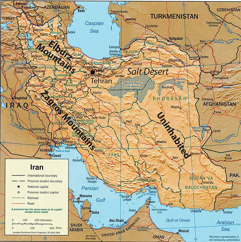
Economic Resources
Iran has abundant oil and natural gas reserves that are being exploited to form the base of their economy. Iran holds about 15 percent of the world’s reserves of natural gas, which is second only to Russia. In 2010, the country was the fourth-largest oil exporter in the world and held about 10 percent of the world’s known oil reserves. The UN has classified Iran’s economy as semi-developed. The government has taken control of the oil and natural gas industry and implemented a type of central planning over many major businesses. Small-scale agriculture and village trading activities are not usually owned by the government. The Caspian Sea provides for fishing and has oil reserves under the seabed. Oil and gas revenues make up most of the state’s income. However, fluctuations in commodity prices have resulted in a more volatile income stream, and Iran’s manufacturing base has been increasing to support a more diversified economy.
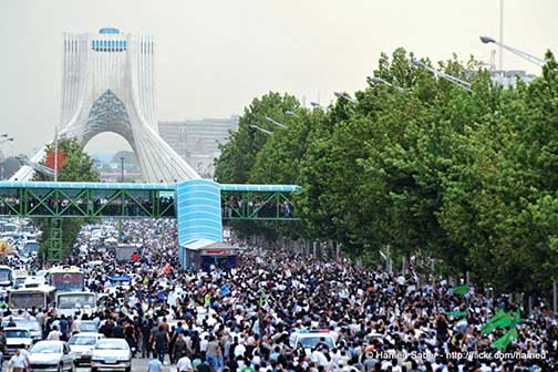
Key Takeaways
- Iraq was ruled by Saddam Hussein from 1979 to 2003. Iraq invaded Kuwait in 1990, which prompted the First Persian Gulf War. Hussein’s use of weapons of mass destruction provoked the US invasion in 2003, which eventually removed Hussein from power.
- The majority Arab population in Iraq shares the country with the Kurds in the north. Sunni and Shia groups have divided the country and opposed each other since the US invasion of 2003.
- Turkey has a relatively stable, democratically elected government. Turkey’s physical geography provides for large supplies of food crops and hydroelectric energy.
- Iran is a religious state that has often been at war or clashed with its Middle Eastern neighbors. Reformers and many young people in Iran would like to see the country become more democratic and more open to personal freedoms.
10.7 Central Asia and Afghanistan
Learning Objectives
- Understand that Central Asia is a landlocked region that receives little rainfall and has to rely on water from major rivers flowing from the mountains in the east.
- Summarize how Central Asia has been transitioning from a Soviet-dominated region to independent states and what has been occurring in the various states to adapt to the new economic environment.
- Describe how the Aral Sea has been affected by the practices of water use in the region and the environmental consequences that have resulted from water use policies.
- Explain the geopolitical history of Afghanistan and why this area has been so difficult to govern under a central government.
- Learn why there is continual conflict in Afghanistan between Western military forces and local Taliban insurgents.
- Understand the principle that globalization of the economy forces political units to compete over natural resources.
A. Central Asia (a.k.a. Turkestan)
Central Asia is a region in the Asian continent that extends from the mountains of western China to the shores of the Caspian Sea. Pakistan and Iran create the southern border of the region, and the vast expanse of Russia is to the north. Afghanistan is considered a part of the region even though it was never a formal part of the Soviet Union. Central Asia was located on what was known as the Silk Road between Europe and the Far East and has long been a crossroads for people, ideas, and trade.
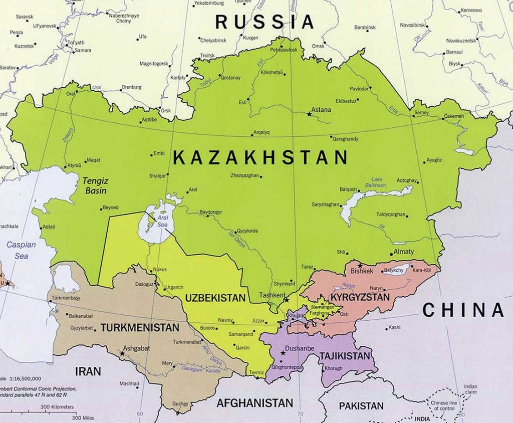
Central Asia has an extremely varied geography, including high mountain passes through vast mountain ranges, such as the Tian Shan, Hindu Kush, and the Pamirs. The region is also home to the vast Kara Kum and Kyzyl Kum Deserts, which dominate the interior with extensive spans of sand and desolation. The expansive treeless, grassy steppes that surround the desert regions are considered an extension of the steppes of Eastern Europe. Some geographers think of the Eurasian Steppes as one single, homogeneous geographical zone.
Under the sand and prairie grasses lay the some of the most extensive untapped reserves of gas and oil on the planet. Natural resources are the main attraction of the region driving the economic forces that determine the development patterns of individual countries. Multinational corporations have vigorously stepped up their activity in the region.
The political systems are adjusting from the old Soviet Union’s socialist policies to new democratic systems that are subject to high levels of authoritarian rule and corruption in business and politics.
The five countries of Kazakhstan, Uzbekistan, Turkmenistan, Tajikistan, and Kyrgyzstan were part of the former Soviet Union until its breakup in 1991. Today, with Afghanistan, they are independent countries that make up the region called Central Asia. The term stan means “land of,” so, for example, Uzbekistan is the land of the Uzbeks. Central Asia is also referred to as Turkestan because of the Turkish influence in the region. The people of Turkey did not originate from the Middle East; they originated from northern Asia. They swept through Central Asia and dominated the region on their way to the Middle East. The Turkish language and heritage have had the most significant impact on the people of Central Asia. Turkmenistan’s name is another reminder of the Turkish connection; it means “the land of the Turkmen.”
Most of the groups of Central Asia were nomadic peoples who rode horses and herded livestock on the region’s vast steppes. This way of life continued until the 1920s, when the Soviet Union forced many of the groups to abandon their lifestyle and settle on collective farms and in cities. Most of the people of Central Asia continue to identify culturally with their nomadic past. Central Asians who live in cities often demonstrate a mix of local and Russian culture in terms of dress and food because of the large influx of Russian populations in the region. More than six million Russians and Ukrainians were resettled into Central Asia during Soviet rule. Russian is often used as a lingua franca.
One of the primary ways in which people distinguish themselves culturally is through religious practices. Despite the area being part of the Soviet Union, where religious activities were discouraged, Islam was and still is the dominant religion. Most Central Asian Muslims are Sunnis.
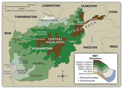
B. Afghanistan
Present-day Afghanistan has been conquered by the likes of Genghis Khan, Alexander the Great, and the Mogul Empire and was a buffer zone for colonial feuds between Russia and British India. The high central mountain range of the Hindu Kush dominates the country and leaves a zone of well-watered fertile plains to the north and a dry desert region to the south. Afghanistan is a remote region without access to the sea and acts as a strategic link between the Middle East and the Far East.
The Soviet Invasion and the Taliban
In 1979, the Soviet Union took advantage of ongoing ethnic warfare in Afghanistan to inject itself into the country. The Soviets pushed in from the north and occupied much of Afghanistan until they completely withdrew in 1989. During the Soviet occupation, the United States supported anti-Communist resistance groups such as the Mujahideen with money, arms, and surface-to-air missiles. The missiles were instrumental in taking out Soviet aircraft and MiG fighters, which caused a critical shift in the balance of power in the war. One of the major connections between the Central Intelligence Agency (CIA) and Mujahideen was a Saudi national named Osama bin Laden. Support from the CIA through bin Laden to the Mujahideen was instrumental in defeating the Soviets.
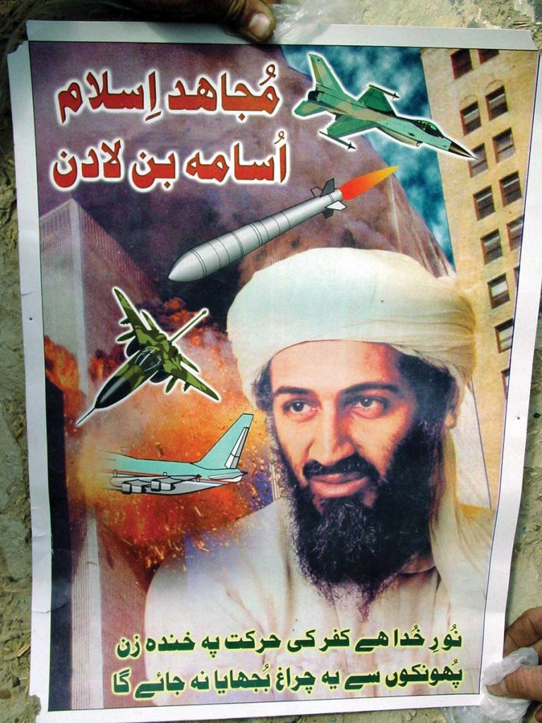
The power vacuum left by the retreating Soviets allowed conflicts to reemerge between the many ethnic factions in Afghanistan. Dozens of languages are spoken in Afghanistan; the top two are Pashtu and Afghan Persian-Dari. There are also a dozen major ethnic groups; the top two are Pashtun and Tajik. The groups regularly fight among themselves, but they have also been known to form alliances. Rural areas are usually led by clan leaders who are not part of any official arm of a national government. Afghanistan is a place where forming any national unity or identity is not easy. The national government in the capital city of Kabul has little influence in the country’s rural regions.
The Soviet invasion brought the internally warring factions together for a short period to focus on the Soviet threat. Chaos and anarchy thrived after the Soviet forces withdrew, but the Islamic fundamentalist group known as the Taliban came forward to fill the power vacuum. One objective of the Taliban was to use Islam as a unifying force to bring the country together. The problem with that concept was that there was much diversity in how Islam was practiced by the numerous local groups. Many of the factions in Afghanistan opposed the Taliban; one such group being the Northern Alliance, which was an association of groups located in the northern portion of the country. The civil war between the Taliban and those that opposed them resulted in the deaths of more than fifty thousand people by 1996 when the Taliban emerged to take power in Kabul. The Taliban is a Sunni Muslim group that adheres to strict Islamic laws under the Wahhabi branch of the faith similar to that of Saudi Arabia. Under Taliban rule, women were removed from positions in hospitals, schools, and work environments and had to wear burkas (also spelled burqas) and be covered from head to toe, including a veil over their faces. Violators were either beaten or shot. The Taliban brought a sense of militant order to Kabul and the regions under their control. Various factions such as the Northern Alliance did not share the Taliban’s strict Islamic views and continued to oppose their position in power.
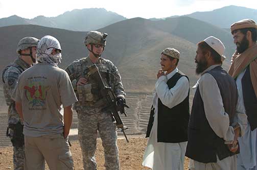
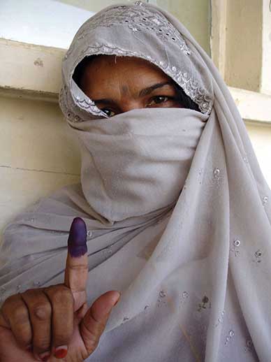
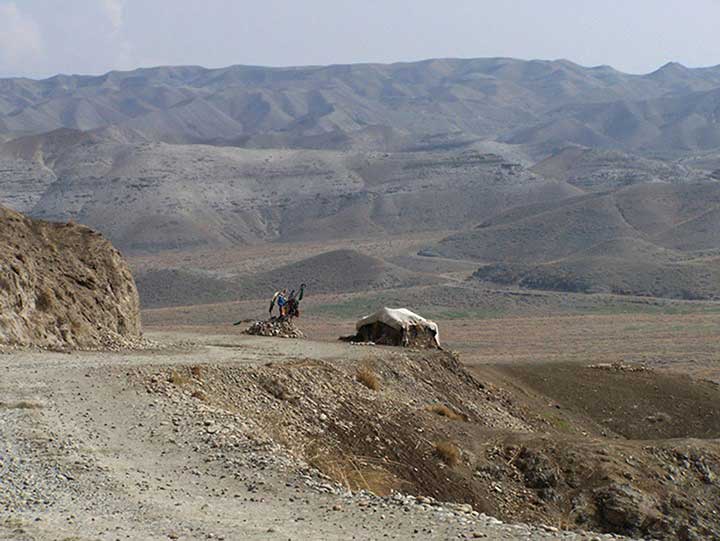
Al-Qaeda and the US Invasion
After the war against the Soviet Union was over, the US role in Afghanistan diminished. The groups that the United States had supported continued to vie for power in local conflicts. Osama bin Laden remained in Afghanistan and established training camps for his version of an anti-Western resistance group called al-Qaeda. Just as he had opposed the Soviet Union, he opposed the United States, even though the United States had supported him against the Soviets. The Saudi government allowed the United States to establish military bases in Saudi Arabia during Operation Desert Storm in the Persian Gulf War, and this was one reason for bin Laden’s opposition; he believed that non-Muslims should not be on the same ground as the Muslim holy sites of Mecca and Medina.
The 9-11 attack in New York City was traced back to al-Qaeda and bin Laden, who was residing in Afghanistan at the time. In a military action dubbed Operation Enduring Freedom, the United States invaded Afghanistan in 2001, removed the Taliban from power, and dismantled the al-Qaeda training camps. Eventually, in 2011, bin Laden was killed by a US Navy Seal at a compound in Pakistan, where bin Laden had been in hiding.
Resources and Globalization
In 2010, a US government report indicated that vast amounts of mineral wealth were discovered in Afghanistan by American geologists and Pentagon officials. Enormous deposits of iron, copper, gold, cobalt, and rare industrial minerals such as lithium are reported to be present in Afghanistan. Total reserves are unknown or have not been released but if extracted would result in trillions of dollars of economic gain for the country. Lithium is highly sought after and is used in the manufacturing of batteries, computers, and electronic devices. The report indicated that Afghanistan could become the world’s premier mining country.
Discovery of vast resources helps place the war in Afghanistan in perspective with respect to global competition over the control of resources. Afghanistan does not have a long-standing tradition of mining. Agriculture has been the main focus of economic activity for the rural communities. A newfound potential for mineral wealth will change the future of Afghanistan. It will be interesting to watch how Afghanistan adapts to and benefits from the discovery of previously unknown resources.
Key Takeaways
- Central Asia is a landlocked region that receives little rainfall. Two large desert regions are located at the region’s core. Vast grasslands called steppes dominate the northern sector. High mountains to the east provide a border between Central Asia and China.
- Central Asia (a.k.a. Turkestan) was dominated by the Soviet Union during the twentieth century. The transition to independence has challenged the region to adjust to changes in political and economic systems.
- The demise of the Aral Sea is being caused by the diversion of water from the two rivers flowing into the sea. A once-thriving fishing industry has been destroyed and environmental damage has been catastrophic.
- Armed conflicts in Afghanistan continue between Western military forces and the Taliban over the control of the country. Clan leaders are a main component of the political fabric of the country. The diversity and fragmentation of the country make it almost impossible to govern.
- Afghanistan is one of the poorest countries in the world based on data on standards of living. However, the country has one of the largest deposits of valuable minerals and ores in the world waiting to be extracted. The deposits are the target of multinational corporations around the globe.
- The following is a summary of trends in Central Asia:
- Shift from Soviet Union to independent states
- Rise in authoritarian governments and corruption
- Increase of cultural influence of Islamic institutions
- Global economic focus on extractive activities
- Increase in military activity over control of resources
- Decline in agriculture as an economic base
- Continued concern for environmental problems
End-of-Chapter Summary
- North Africa, Southwest Asia, and Central Asia (Turkestan) are included in a the realm of North Africa and Southwest Asia, which is dominated by the religion of Islam, arid type B climates, and the export of oil and natural gas. Large, expansive deserts make up most of the physical areas of all three regions of the realm. Water is of particular importance, as most of the population has traditionally made a living from agriculture. Division, warfare, and conflict have been constant elements. The Arab Spring of 2011 included a wave of mass citizen demonstrations in many Arab countries where the people demanded political and economic reform.
- The three main monotheistic religions of Judaism, Christianity, and Islam emerged from the Middle East and can be traced back to a common patriarch, Abraham. Most of the people in the realm are Muslims. The Five Pillars of Islam create a guide for Muslims to live by. Mecca, the holiest city for Muslims worldwide, is where the prophet Muhammad started the religion. The two main divisions of Islam are Sunni (84 percent) and Shia (15 percent). Other smaller divisions exist, such as Sufi.
- North Africa includes the countries bordering the Mediterranean Sea and Sudan on the Red Sea. Most of the people in North Africa are Muslims. The high-population areas are along the coast or along the Nile River. The Maghreb is included in the region with the Atlas Mountains in the west. The Atlas Mountains trap moisture, which provides precipitation for agriculture in the mountain valleys. The countries of North Africa have all witnessed political uprisings in which the people have demanded democratic reforms and increased civil rights. Egypt is the most populous Arab country and the cornerstone of the Arab world.
- The African Transition Zone is where the dry, arid conditions of the Sahara Desert meet the tropical conditions of Equatorial Africa. Islam is dominant in the north, and Christianity and tribal religions are dominant in the south. Sudan is one place where the two sides have clashed in warfare and division. Tribal Christian southern Sudan separated from the Arab Muslim north to create the independent country of South Sudan. Ethnic cleansing has been witnessed in the western part of Sudan in the region of Darfur.
- Palestine was divided in half in 1945 into an Arab state and a Jewish state. The Jewish state became the nation of Israel in 1948. Since that time, there has been a constant struggle between the mainly Arab Palestinians and the Jewish State of Israel. The West Bank and the Gaza Strip are Palestinian regions that have worked to be recognized with equal sovereignty. The solution to this division is debated; both sides have claims that are incompatible with each other. The neighboring Arab states of Jordan, Syria, and Lebanon have their own unique political situations.
- The Arabian Peninsula includes a number of states ruled by a single king, sultan, emir, or sheik, except Yemen, which has a democratically elected president. Saudi Arabia is the home of the two main cities of Islam, Mecca and Medina. Saudi Arabia is the largest country on the peninsula and has about 25 percent of all the known oil reserves in the world. Oil and natural gas are the main export products and the main source of income for the region.
- Most people in Turkey are of Turkish ethnicity, and most people in Iran are of Persian ethnicity. The country of Turkey is what remains from the once expansive Ottoman Empire. Iran is a country of mountains and deserts that was once the center of the Persian Empire. Turkey has a portion of its country in Europe, and its largest part includes the expansive Anatolian Plateau in Asia. Turkey is a democratic republic with elected public officials. Iran is a religious state in which the Islamic leadership controls who can be included in the government. Both countries have large populations of about seventy million each.
- Iraq was at the center of the Fertile Crescent of Mesopotamia, which spawned early human civilizations. Iraq was invaded by the United States in 2003 and has been working to establish a democratic government. The country is divided between a Shia majority and a Sunni minority. It is an Arab country with a large minority group of Kurds in the north. Iraq has enormous oil reserves that have not yet been developed for exploitation, which has attracted the attention of the world’s energy-dependent core regions.
- Central Asia (Turkestan) is a landlocked region with mainly type B climates with cooler temperatures in the higher elevations of the eastern mountains. The prominently Muslim region has been transitioning from a Soviet-controlled domain to independent states. Some countries are making the transition with less difficulty than others. The Aral Sea has been one of the major environmental disasters in modern history. Globalization activities have targeted the region for its immense amount of natural resources—mainly oil, natural gas, and minerals.
- Afghanistan has been conquered by many empires and was a buffer state between British and Russian colonial efforts. The country has a dry, rugged terrain and a devastated economy. The people are poor with little infrastructure. The many tribal groups have made it difficult for a centralized government to be effective. The United States invaded Afghanistan in 2001 to remove al-Qaeda training camps run by Osama bin Laden. North Atlantic Treaty Organization (NATO) forces have taken over the mission in Afghanistan to defeat the Taliban extremists and support stability for the country. Afghanistan has enormous amounts of mineral resources that are in high demand by the world’s core industrial regions.